IMAGES TAKEN NEAR TO
Eccles Road, IPSWICH, IP2 9RE
Introduction
This page details the photographs taken nearby to Eccles Road, IP2 9RE by members of the Geograph project.
The Geograph project started in 2005 with the aim of publishing, organising and preserving representative images for every square kilometre of Great Britain, Ireland and the Isle of Man.

There are currently over 7.5m images from over14,400 individuals and you can help contribute to the project by visiting https://www.geograph.org.uk
Image Map
Images are licensed for reuse under creativecommons.org/licenses/by-sa/2.0
Notes
- Clicking on the map will re-center to the selected point.
- The higher the marker number, the further away the image location is from the centre of the postcode.
Image Listing (38 Images Found)
Images are licensed for reuse under creativecommons.org/licenses/by-sa/2.0
Image
Details
Distance
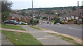
1
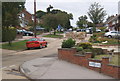
Radcliffe Drive continues rising beyond Clifton Way junction
A pleasant residential street in south-west Ipswich, IP2.
Image: © Andrew Hill
Taken: 18 Jul 2008
0.05 miles
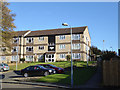
2
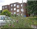
Flats in Hale Close, Chantry, south-west Ipswich
Oak House is one of three similar blocks, the others being Beech House and Ash House. Postal area is IP2.
Image: © Andrew Hill
Taken: 18 Jul 2008
0.12 miles
3
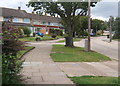
Looking up Radcliffe Drive
A residential area of south-west Ipswich, IP2. This part of Ipswich is actually quite hilly (at least by Suffolk standards).
Image: © Andrew Hill
Taken: 18 Jul 2008
0.12 miles
4
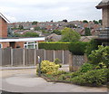
Chantry area of south-west Ipswich
Large residential development, mainly modern, in IP2 postal area.
Image: © Andrew Hill
Taken: 18 Jul 2008
0.14 miles
5
10 - 32 Pin Mill Close
The right-hand end.
Image: © Robin Webster
Taken: 19 Nov 2017
0.16 miles
6
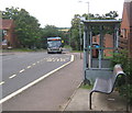
Bus stop, Belmont Road
Near the edge of the south-western residential area of Ipswich, IP8.
Image: © Andrew Hill
Taken: 18 Jul 2008
0.17 miles
7
Looking down Bridgwater Road, Chantry, Ipswich
View to the countryside beyond.
Image: © Andrew Hill
Taken: 18 Jul 2008
0.17 miles
8
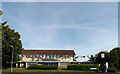
Belstead Arms Public House
On Radcliffe Drive at the junction with Ellenbrook Road
https://www.facebook.com/pages/The-Belstead-Arms/148693511834645
Image: © Geographer
Taken: 21 Aug 2014
0.18 miles
9
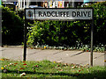
Radcliffe Drive sign
On Radcliffe Drive at the junction with Ellenbrook Road
Image: © Geographer
Taken: 21 Aug 2014
0.19 miles
10
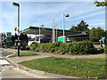
Snax 24 Fuel Filling Station on Ellenbrook Road
Image: © Geographer
Taken: 21 Aug 2014
0.19 miles