IMAGES TAKEN NEAR TO
Plover Road, IPSWICH, IP2 9ND
Introduction
This page details the photographs taken nearby to Plover Road, IP2 9ND by members of the Geograph project.
The Geograph project started in 2005 with the aim of publishing, organising and preserving representative images for every square kilometre of Great Britain, Ireland and the Isle of Man.

There are currently over 7.5m images from over14,400 individuals and you can help contribute to the project by visiting https://www.geograph.org.uk
Image Map
Images are licensed for reuse under creativecommons.org/licenses/by-sa/2.0
Notes
- Clicking on the map will re-center to the selected point.
- The higher the marker number, the further away the image location is from the centre of the postcode.
Image Listing (16 Images Found)
Images are licensed for reuse under creativecommons.org/licenses/by-sa/2.0
Image
Details
Distance
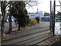
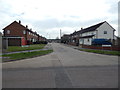
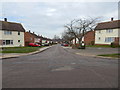
1
Flats on Birkfield Drive, Chantry
Looking north towards the junction with Mallard Way.
Image: © Simon Mortimer
Taken: 11 Sep 2020
0.09 miles
2
Heron Road
A side road off Sheldrake Drive.
Image: © Hamish Griffin
Taken: 6 Mar 2014
0.15 miles
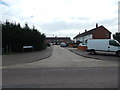
3
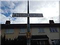
Sheldrake Drive sign
Opposite Gannet Road.
Image: © Hamish Griffin
Taken: 6 Mar 2014
0.15 miles
4
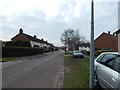
Sheldrake Drive from Heron Road junction
Looking towards Ellenbrook Road.
Image: © Hamish Griffin
Taken: 6 Mar 2014
0.16 miles
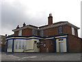
5
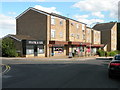
Shops in Cambridge Drive
Including the Chipswich fish & chip shop
Image: © Keith Edkins
Taken: 8 Aug 2018
0.17 miles
6
Gannet Road
A side road off Sheldrake Drive.
Image: © Hamish Griffin
Taken: 6 Mar 2014
0.17 miles
7
Kittiwake Close
A dead end road off Sheldrake Drive.
Image: © Hamish Griffin
Taken: 6 Mar 2014
0.19 miles