IMAGES TAKEN NEAR TO
Prince Of Wales Drive, IPSWICH, IP2 9BN
Introduction
This page details the photographs taken nearby to Prince Of Wales Drive, IP2 9BN by members of the Geograph project.
The Geograph project started in 2005 with the aim of publishing, organising and preserving representative images for every square kilometre of Great Britain, Ireland and the Isle of Man.

There are currently over 7.5m images from over14,400 individuals and you can help contribute to the project by visiting https://www.geograph.org.uk
Image Map
Images are licensed for reuse under creativecommons.org/licenses/by-sa/2.0
Notes
- Clicking on the map will re-center to the selected point.
- The higher the marker number, the further away the image location is from the centre of the postcode.
Image Listing (32 Images Found)
Images are licensed for reuse under creativecommons.org/licenses/by-sa/2.0
Image
Details
Distance
1
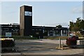
Halifax Primary School, Ipswich
The school building was designed by celebrated Ipswich architect Birkin Haward (1912-2002) using an innovative open plan design. It was opened in 1971 by the then Secretary of State for Education, Margaret Thatcher.
Image: © Simon Mortimer
Taken: 10 Sep 2020
0.05 miles
3
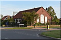
Stoke Green Baptist Church
The church building dates back to 1954 when the estate of Maiden Hall was developed for housing. The church itself has a longer history and is the second oldest baptist church in Suffolk. From 1775 it occupied a building on Wherstead Road where Peppercorn Way is now, although the congregation had been meeting for a few decades before that, originally in Woolverstone.
Image: © Simon Mortimer
Taken: 10 Sep 2020
0.20 miles
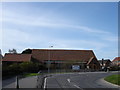
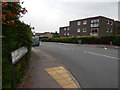
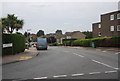
4
Open area on Stoke Park Drive
Crowland Close can be seen on the right.
Image: © Hamish Griffin
Taken: 4 Sep 2014
0.20 miles
6
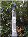
Lamp post N398
On Belstead Road. Also with a no fouling sign and a smiley face.
Image: © Hamish Griffin
Taken: 4 Sep 2014
0.21 miles
7
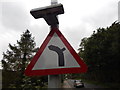
Bend to the left with side road to the right sign
Close up of Image
Image: © Hamish Griffin
Taken: 4 Sep 2014
0.21 miles
8
Bend to the left with side road to the right sign
The "road to the right" is actually called Belstead Road, the road continues to the left as Stoke Park Drive.
Image: © Hamish Griffin
Taken: 4 Sep 2014
0.21 miles
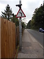
10
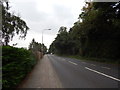
Belstead Road
Just after the Heatherhayes junction, looking towards the main St Joseph's College entrance.
Image: © Hamish Griffin
Taken: 4 Sep 2014
0.22 miles