IMAGES TAKEN NEAR TO
Kesteven Road, IPSWICH, IP2 9AQ
Introduction
This page details the photographs taken nearby to Kesteven Road, IP2 9AQ by members of the Geograph project.
The Geograph project started in 2005 with the aim of publishing, organising and preserving representative images for every square kilometre of Great Britain, Ireland and the Isle of Man.

There are currently over 7.5m images from over14,400 individuals and you can help contribute to the project by visiting https://www.geograph.org.uk
Image Map
Images are licensed for reuse under creativecommons.org/licenses/by-sa/2.0
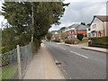
Notes
- Clicking on the map will re-center to the selected point.
- The higher the marker number, the further away the image location is from the centre of the postcode.
Image Listing (279 Images Found)
Images are licensed for reuse under creativecommons.org/licenses/by-sa/2.0
Image
Details
Distance
1
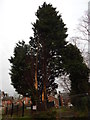
Damaged tree on Ancaster Road
It was probably damaged in the October 2013 St. Jude storm.
Image: © Hamish Griffin
Taken: 7 Mar 2014
0.05 miles
2
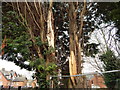
Damaged tree on Ancaster Road (close up)
Close up of http://www.geograph.org.uk/photo/3877903.
Image: © Hamish Griffin
Taken: 7 Mar 2014
0.05 miles
3
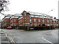
Howard House, Ipswich
In the 1940s this area just south of the railway station consisted of a number of disused sand and gravel pits.
Image: © Evelyn Simak
Taken: 29 Jan 2012
0.06 miles
4
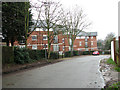
Howard House in Gippeswyck Avenue, Ipswich
This large building contains flats. Like the adjoining buildings, it was constructed on the site of disused sand and gravel pits.
Image: © Evelyn Simak
Taken: 29 Jan 2012
0.07 miles
5
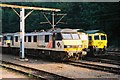
Freightliner Locomotives stabled at Ipswich
Co-Co Diesel locomotives Class 66/5 number 66578 and Class 66/9 number 66955 rest with Bo-Bo Electric locomotives Class 90/0 numbers 90042 and 90016 in the sidings south of the station.
Image: © Roger Templeman
Taken: 19 Sep 2009
0.08 miles
6
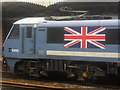
Railways celebrating the Queen's Diamond Jubilee
A train motor unit, named the Diamond Jubilee and adorned on each side with a Union flag, stands at Ipswich station as part of a London Liverpool Street to Norwich service.
The geometric construction of the flag is not quite correct though. A closer look at the corners shows that the saltires of St. Patrick and St. Andrew have been allowed to paddle around the corner. The edges of the saltires should meet on the diagonal line through the flag.
Image: © Ed of the South
Taken: 10 Jul 2012
0.08 miles
7
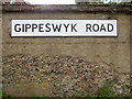
Gippeswyk Road sign
Sign for http://www.geograph.org.uk/photo/3878116.
Image: © Hamish Griffin
Taken: 7 Mar 2014
0.08 miles
8
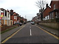
Gippeswyk Road, Ipswich
Gippeswyk Avenue is behind. Ancaster Road takes over Gippeswyk Avenue here and becomes a tarmac road, rather than a dirt track.
Image: © Hamish Griffin
Taken: 7 Mar 2014
0.09 miles
9
Gippeswyk Avenue
The corner of Gippeswyk Park can be seen on the right.
Image: © Hamish Griffin
Taken: 20 Oct 2014
0.09 miles
10
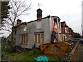
Derelict house on Gippeswyk Road, Ipswich
This derelict house is currently having work done on it.
Image: © Hamish Griffin
Taken: 7 Mar 2014
0.09 miles