IMAGES TAKEN NEAR TO
The Oaks, BURY ST. EDMUNDS, IP29 5SH
Introduction
This page details the photographs taken nearby to The Oaks, IP29 5SH by members of the Geograph project.
The Geograph project started in 2005 with the aim of publishing, organising and preserving representative images for every square kilometre of Great Britain, Ireland and the Isle of Man.

There are currently over 7.5m images from over14,400 individuals and you can help contribute to the project by visiting https://www.geograph.org.uk
Image Map
Images are licensed for reuse under creativecommons.org/licenses/by-sa/2.0
Notes
- Clicking on the map will re-center to the selected point.
- The higher the marker number, the further away the image location is from the centre of the postcode.
Image Listing (51 Images Found)
Images are licensed for reuse under creativecommons.org/licenses/by-sa/2.0
Image
Details
Distance
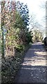
2
Part of Manor Lane
The buildings are part of Horringer Manor.
Image: © Robert Edwards
Taken: 13 Jul 2009
0.16 miles
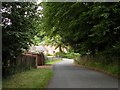
3
Horringer, No 1 Lady Bristols' Cottages
There is a benchmark cut into the west facing wall of the house and is cut into the left corner bricks of the property.
Image: © Mel Towler
Taken: 7 Jul 2022
0.18 miles
4
![Horringer features [1]](https://s2.geograph.org.uk/geophotos/06/76/08/6760838_3faca05e_120x120.jpg)
Horringer features [1]
This delightful thatched village sign stands on the corner of The Street and Meadow Drive.
The small village of Horringer, earlier known as Horningsheath lies astride the A143 road some two miles south west of Bury St Edmunds. The village includes the main entrance to Ickworth Park. There was once three blacksmiths’ forges in the village.
Image: © Michael Dibb
Taken: 15 Sep 2020
0.18 miles
5
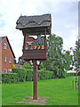
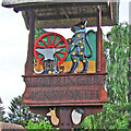
Horringer village sign
At the time of writing the sign is not in situ and is under repair after being blown down. Erected for the silver jubilee of Queen Elizabeth II, the sign has a thatched roof under which is an ounce, (panther) which are supporters on the coat of arms of the Marquesses of Bristol. Also depicted is a cartwheel, an anvil and tools representing the wheelwright and blacksmiths and other tradesmen of the past. Behind the wheel is a branch of oak is representative of the Tea Party Oak in Ickworth Park. In the left bottom corner is a sickle and fork representing the agricultural and horticultural aspect of the parish. An artist’s palette, almost hidden reflects the Horringer Crafts group. On the spandrels are a deer and a black faced Suffolk sheep, representing the two types of animal to be found in Ickworth Park.
Image: © Adrian S Pye
Taken: 29 Apr 2007
0.18 miles
6
Horringer cum Ickworth village sign (detail)
At the time of writing the sign is not in situ and is under repair after being blown down. Erected for the silver jubilee of Queen Elizabeth II, the sign has a thatched roof under which is an ounce, (panther) which are supporters on the coat of arms of the Marquesses of Bristol. Also depicted is a cartwheel, an anvil and tools representing the wheelwright and blacksmiths and other tradesmen of the past. Behind the wheel is a branch of oak is representative of the Tea Party Oak in Ickworth Park. In the left bottom corner is a sickle and fork representing the agricultural and horticultural aspect of the parish. An artist’s palette, almost hidden reflects the Horringer Crafts group. On the spandrels are a deer and a black faced Suffolk sheep, representing the two types of animal to be found in Ickworth Park.
Image: © Adrian S Pye
Taken: 29 Apr 2007
0.18 miles
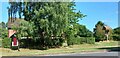
7
![Horringer houses [10]](https://s1.geograph.org.uk/geophotos/06/76/08/6760841_c08fd0e6_120x120.jpg)
Horringer houses [10]
Weavers Cottages, The Street, is 16th century, timber framed and plastered and jettied to the street. Originally one house it was divided into three cottages with, at one time, 40 inhabitants. Part of it once housed a Dame School. The ceilings downstairs are particularly fine. Listed, grade II, with details at: https://historicengland.org.uk/listing/the-list/list-entry/1186988
The small village of Horringer, earlier known as Horningsheath lies astride the A143 road some two miles south west of Bury St Edmunds. The village includes the main entrance to Ickworth Park. There was once three blacksmiths’ forges in the village.
Image: © Michael Dibb
Taken: 15 Sep 2020
0.18 miles
9
![Horringer houses [9]](https://s0.geograph.org.uk/geophotos/06/76/08/6760836_b161974c_120x120.jpg)
Horringer houses [9]
Pheasant Cottage, The Street, is 17th century, timber framed and plastered with a thatched roof. Alterations were made in circa 1840. Listed, grade II, with details at: https://historicengland.org.uk/listing/the-list/list-entry/1298944
The small village of Horringer, earlier known as Horningsheath lies astride the A143 road some two miles south west of Bury St Edmunds. The village includes the main entrance to Ickworth Park. There was once three blacksmiths’ forges in the village.
Image: © Michael Dibb
Taken: 15 Sep 2020
0.19 miles
10
![Horringer houses [11]](https://s3.geograph.org.uk/geophotos/06/76/08/6760875_9a856ec2_120x120.jpg)
Horringer houses [11]
Once known as Highlands, The Old Rectory in The Street is 15th and early 16th century with early 17th and mid 18th century alterations. Timber framed and plastered. Originally jettied to the street, now only the left-hand bay has retained the jetty. The open hall attached to the jettied wing was demolished circa 1530 and replaced with the existing main range of hall and parlour. There were additions in the 17th century. There are some fine internal original features. The Old Rectory was built in the 16th century when parish priests were expected to provide accommodation for travellers. In 1873 a new rectory was built, and in 1877 the building became the Horringer and Ickworth Working Men’s Club. Listed, grade II, with details at: https://historicengland.org.uk/listing/the-list/list-entry/1186989
The small village of Horringer, earlier known as Horningsheath lies astride the A143 road some two miles south west of Bury St Edmunds. The village includes the main entrance to Ickworth Park. There was once three blacksmiths’ forges in the village.
, with complex roll mouldings and hollow chamfers to 1st and attic floor members. A further parlour was added early C17 to rear, with complete oak wainscotting. In mid C18 the chimney between hall and parlour rebuilt, vaulting over new entrance hall, with staircase having moulded handrail and turned newels and balusters; other mid-C18 joinery including panelled doors and cornices.
Image: © Michael Dibb
Taken: 15 Sep 2020
0.19 miles