IMAGES TAKEN NEAR TO
Chedburgh Road, BURY ST. EDMUNDS, IP29 5QS

Introduction

This page details the photographs taken nearby to Chedburgh Road, IP29 5QS by members of the Geograph project.

The Geograph project started in 2005 with the aim of publishing, organising and preserving representative images for every square kilometre of Great Britain, Ireland and the Isle of Man.

There are currently over 7.5m images from over14,400 individuals and you can help contribute to the project by visiting https://www.geograph.org.uk

Image Map


Images are licensed for reuse under creativecommons.org/licenses/by-sa/2.0
Notes
  • Clicking on the map will re-center to the selected point.
  • The higher the marker number, the further away the image location is from the centre of the postcode.

Image Listing (10 Images Found)

Images are licensed for reuse under creativecommons.org/licenses/by-sa/2.0
Image
Details
Distance
1
Chevington village hall
Image: © Adrian S Pye Taken: 28 Aug 2015
0.05 miles
2
Chevington village sign
The sign is close by the village hall
Image: © Adrian S Pye Taken: 28 Aug 2015
0.06 miles
3
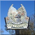
Chevington village sign
The sign which is based on a horseshoe with eleven nail holes. (usually 6 to 8) depicts the Abbot, John de Norwold, who owned 460 acres of arable land in Chevington, 8 acres of meadow, 4 acres of wood and a windmill so he could collect the tythes and enjoy a life sitting about doing nothing. The sign is decorated with ears of wheat, poppies and daisies.
Image: © Adrian S Pye Taken: 26 Feb 2021
0.06 miles
4
Chevington village hall
The village sign is located beside the steps up to the entrance. https://www.geograph.org.uk/photo/6767883
Image: © Adrian S Pye Taken: 26 Feb 2021
0.06 miles
5
Chevington's village hall and village sign
Image: © Robert Edwards Taken: 10 Jul 2009
0.07 miles
6
Broad Green, Chevington
The centre of the small village of Chevington, with the Greyhound pub, famous for its 'Force 12' curries, on the left.
Image: © Bob Jones Taken: 2 Jun 2006
0.12 miles
7
The Greyhound, Chevington
http://www.geograph.org.uk/photo/4635676
Image: © Adrian S Pye Taken: 28 Aug 2015
0.17 miles
8
The sign of The Greyhound public house
http://www.geograph.org.uk/photo/4635674
Image: © Adrian S Pye Taken: 28 Aug 2015
0.17 miles
9
Approaching The Crossroads
Approaching the crossroads at Chevington, Suffolk.
Image: © Keith Evans Taken: 17 Feb 2011
0.17 miles
10
Tan Office Green, Chevington
Factory Lane leads to Stonehouse Farm. Was this once a tanning factory?
Image: © Bob Jones Taken: 2 Jun 2006
0.19 miles