IMAGES TAKEN NEAR TO
Chevington, BURY ST. EDMUNDS, IP29 5QQ
Introduction
This page details the photographs taken nearby to IP29 5QQ by members of the Geograph project.
The Geograph project started in 2005 with the aim of publishing, organising and preserving representative images for every square kilometre of Great Britain, Ireland and the Isle of Man.

There are currently over 7.5m images from over14,400 individuals and you can help contribute to the project by visiting https://www.geograph.org.uk
Image Map
Images are licensed for reuse under creativecommons.org/licenses/by-sa/2.0
Notes
- Clicking on the map will re-center to the selected point.
- The higher the marker number, the further away the image location is from the centre of the postcode.
Image Listing (6 Images Found)
Images are licensed for reuse under creativecommons.org/licenses/by-sa/2.0
Image
Details
Distance
1
Cottages
Cottages near to Chevington, Suffolk.
Image: © Keith Evans
Taken: 28 Nov 2010
0.01 miles
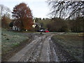
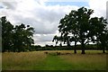
2
Track out of the Ickworth estate towards Chevington
Image: © Christopher Hilton
Taken: 9 Aug 2015
0.06 miles
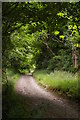
3
Entering Ickworth Estate
Entering the Ickworth Estate near to Chevington, Suffolk.
Image: © Keith Evans
Taken: 28 Nov 2010
0.13 miles
4
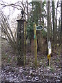
Two Signs One Gate Post
Footpath sign, National Trust sign and old gate post near to Chevington, Suffolk.
Image: © Keith Evans
Taken: 28 Nov 2010
0.13 miles
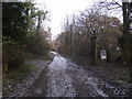
5
Lownde Wood, Ickworth
Looking south east towards Lownde Wood along a path created under the Countryside Access Scheme, whereby set-aside land can be used for recreational purposes.
Image: © Bob Jones
Taken: 3 Aug 2005
0.15 miles
6
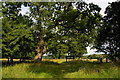
Ickworth Park: near Downter's Wood
Image: © Christopher Hilton
Taken: 9 Aug 2015
0.25 miles