IMAGES TAKEN NEAR TO
Factory Lane, BURY ST. EDMUNDS, IP29 5QF
Introduction
This page details the photographs taken nearby to Factory Lane, IP29 5QF by members of the Geograph project.
The Geograph project started in 2005 with the aim of publishing, organising and preserving representative images for every square kilometre of Great Britain, Ireland and the Isle of Man.

There are currently over 7.5m images from over14,400 individuals and you can help contribute to the project by visiting https://www.geograph.org.uk
Image Map
Images are licensed for reuse under creativecommons.org/licenses/by-sa/2.0
Notes
- Clicking on the map will re-center to the selected point.
- The higher the marker number, the further away the image location is from the centre of the postcode.
Image Listing (5 Images Found)
Images are licensed for reuse under creativecommons.org/licenses/by-sa/2.0
Image
Details
Distance
1
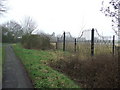
Impressive Gates
Impressive gates on Factory Lane near to Tan Office Green, Suffolk.
Image: © Keith Evans
Taken: 17 Feb 2011
0.03 miles
2

Factory Lane
Factory Lane near to Tan Office Green, Suffolk.
Image: © Keith Evans
Taken: 17 Feb 2011
0.10 miles
3
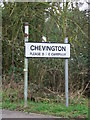
Please D i e Carefully
Road sign seen at Chevington, Suffolk.
Image: © Keith Evans
Taken: 17 Feb 2011
0.10 miles
4
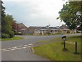
Tan Office Green, Chevington
Factory Lane leads to Stonehouse Farm. Was this once a tanning factory?
Image: © Bob Jones
Taken: 2 Jun 2006
0.12 miles
5
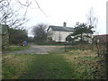
Stonehouse Farm
Stonehouse Farm near to Chevington, Suffolk.
Image: © Keith Evans
Taken: 17 Feb 2011
0.18 miles