IMAGES TAKEN NEAR TO
Sharps Green, BURY ST. EDMUNDS, IP29 5PP
Introduction
This page details the photographs taken nearby to Sharps Green, IP29 5PP by members of the Geograph project.
The Geograph project started in 2005 with the aim of publishing, organising and preserving representative images for every square kilometre of Great Britain, Ireland and the Isle of Man.

There are currently over 7.5m images from over14,400 individuals and you can help contribute to the project by visiting https://www.geograph.org.uk
Image Map
Images are licensed for reuse under creativecommons.org/licenses/by-sa/2.0
Notes
- Clicking on the map will re-center to the selected point.
- The higher the marker number, the further away the image location is from the centre of the postcode.
Image Listing (7 Images Found)
Images are licensed for reuse under creativecommons.org/licenses/by-sa/2.0
Image
Details
Distance
5
![Horringer houses [8]](https://s0.geograph.org.uk/geophotos/06/76/08/6760832_bc303c56_120x120.jpg)
Horringer houses [8]
West Gates, The Street, is a substantial Victorian house in red brick with a gault brick front.
The small village of Horringer, earlier known as Horningsheath lies astride the A143 road some two miles south west of Bury St Edmunds. The village includes the main entrance to Ickworth Park. There was once three blacksmiths’ forges in the village.
Image: © Michael Dibb
Taken: 15 Sep 2020
0.24 miles
6
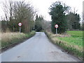
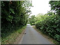
Speed Restriction
Entering Horringer, Suffolk on Sharp's Lane.
Image: © Keith Evans
Taken: 12 Jan 2012
0.24 miles
7
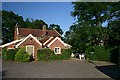
The Beehive, Horringer
Rear of the Beehive public house, from the car park.
Image: © Bob Jones
Taken: 27 Jun 2005
0.24 miles