IMAGES TAKEN NEAR TO
Nowton, BURY ST. EDMUNDS, IP29 5NF
Introduction
This page details the photographs taken nearby to IP29 5NF by members of the Geograph project.
The Geograph project started in 2005 with the aim of publishing, organising and preserving representative images for every square kilometre of Great Britain, Ireland and the Isle of Man.

There are currently over 7.5m images from over14,400 individuals and you can help contribute to the project by visiting https://www.geograph.org.uk
Image Map
Images are licensed for reuse under creativecommons.org/licenses/by-sa/2.0
Notes
- Clicking on the map will re-center to the selected point.
- The higher the marker number, the further away the image location is from the centre of the postcode.
Image Listing (25 Images Found)
Images are licensed for reuse under creativecommons.org/licenses/by-sa/2.0
Image
Details
Distance
7
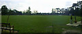
Nowton Cricket Club pitch
Two photo panorama of the pitch, including the patio in front of the club house.
Image: © John Goldsmith
Taken: 24 Feb 2006
0.15 miles
8

Rounders at the cricket club, Nowton
Nowton Cricket Club hosts a game of rounders, at a company fun day.
Nowton is a small village but its cricket club seems to attract people from a wide area, including its far larger neighbour, Bury St. Edmunds.
The ground is tucked away down a dirt track and largely surrounded by trees.
Image: © John Goldsmith
Taken: 15 Jul 2007
0.16 miles