IMAGES TAKEN NEAR TO
Church Lane, BURY ST. EDMUNDS, IP29 5HH
Introduction
This page details the photographs taken nearby to Church Lane, IP29 5HH by members of the Geograph project.
The Geograph project started in 2005 with the aim of publishing, organising and preserving representative images for every square kilometre of Great Britain, Ireland and the Isle of Man.

There are currently over 7.5m images from over14,400 individuals and you can help contribute to the project by visiting https://www.geograph.org.uk
Image Map
Images are licensed for reuse under creativecommons.org/licenses/by-sa/2.0
Notes
- Clicking on the map will re-center to the selected point.
- The higher the marker number, the further away the image location is from the centre of the postcode.
Image Listing (9 Images Found)
Images are licensed for reuse under creativecommons.org/licenses/by-sa/2.0
Image
Details
Distance
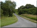
1
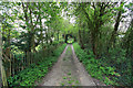
The Wash, Hargrave
A low-lying area, north of Hargrave. The road ahead leads to Hargrave Church.
Image: © Bob Jones
Taken: 4 Aug 2005
0.06 miles
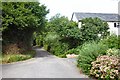
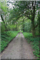
3
The road to Hargrave village from The Wash
Image: © Robert Edwards
Taken: 13 Jul 2009
0.10 miles

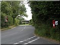
5

Turn left for National Cycle Route 51
Minor road junction, The Wash.
Image: © JThomas
Taken: 21 May 2016
0.11 miles
6
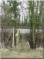
Footbridge
Footbridge near to Hargrave, Suffolk.
Image: © Keith Evans
Taken: 17 Feb 2011
0.20 miles
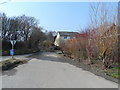
8
The road from Hargrave Hall and church
Image: © Robert Edwards
Taken: 13 Jul 2009
0.23 miles