IMAGES TAKEN NEAR TO
Barrow, BURY ST. EDMUNDS, IP29 5BB
Introduction
This page details the photographs taken nearby to IP29 5BB by members of the Geograph project.
The Geograph project started in 2005 with the aim of publishing, organising and preserving representative images for every square kilometre of Great Britain, Ireland and the Isle of Man.

There are currently over 7.5m images from over14,400 individuals and you can help contribute to the project by visiting https://www.geograph.org.uk
Image Map
Images are licensed for reuse under creativecommons.org/licenses/by-sa/2.0
Notes
- Clicking on the map will re-center to the selected point.
- The higher the marker number, the further away the image location is from the centre of the postcode.
Image Listing (6 Images Found)
Images are licensed for reuse under creativecommons.org/licenses/by-sa/2.0
Image
Details
Distance
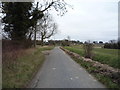
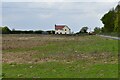
2
Entering Barrow
Heading south east on Coalpit Lane.
Image: © JThomas
Taken: 19 Mar 2016
0.03 miles
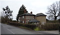
3
Higham: Entrance to Grove Farm from Coalpit Lane
Image: © Michael Garlick
Taken: 13 May 2021
0.03 miles
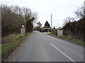
5
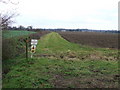
Footpath Corner
Footpath bend to the right near to Higham, Suffolk.
Image: © Keith Evans
Taken: 27 Jan 2011
0.20 miles