IMAGES TAKEN NEAR TO
Stirling Close, BURY ST. EDMUNDS, IP29 4WD
Introduction
This page details the photographs taken nearby to Stirling Close, IP29 4WD by members of the Geograph project.
The Geograph project started in 2005 with the aim of publishing, organising and preserving representative images for every square kilometre of Great Britain, Ireland and the Isle of Man.

There are currently over 7.5m images from over14,400 individuals and you can help contribute to the project by visiting https://www.geograph.org.uk
Image Map
Images are licensed for reuse under creativecommons.org/licenses/by-sa/2.0
Notes
- Clicking on the map will re-center to the selected point.
- The higher the marker number, the further away the image location is from the centre of the postcode.
Image Listing (29 Images Found)
Images are licensed for reuse under creativecommons.org/licenses/by-sa/2.0
Image
Details
Distance
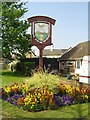
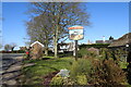
2
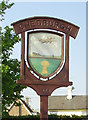
Chedburgh Village sign on The Green
(close up)
Image: © Geographer
Taken: 3 Oct 2014
0.15 miles
5
Chedburgh village sign
http://www.geograph.org.uk/photo/4291589
Image: © Adrian S Pye
Taken: 30 Apr 2007
0.15 miles
6
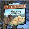
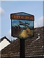
Chedburgh village sign
The sign depicts an Avro Lancaster of the type based at RAF Chedburgh during World War II. Below and on the ground, are a pair of heavy horses ploughing the fertile clay soil and a wheatsheaf standing in a field. It is the result of their yearlong labours and symbolic of the agricultural heritage of the parish. https://www.geograph.org.uk/photo/6767890
The sign replaced an earlier version https://www.geograph.org.uk/photo/4291589 with the same theme.
Image: © Adrian S Pye
Taken: 26 Feb 2021
0.15 miles
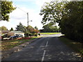
7
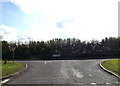
The Green, Chedburgh
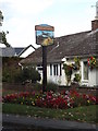
At the junction with the A143 Bury Road
Image: © Geographer
Taken: 3 Oct 2014
0.15 miles
8
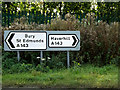
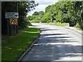
Roadsigns on the A143 Bury Road
At the junction with The Green
Image: © Geographer
Taken: 3 Oct 2014
0.15 miles
9
Chedburgh village sign
The sign depicts an Avro Lancaster of the type based at RAF Chedburgh during World War II. Below and on the ground, are a pair of heavy horses ploughing the fertile clay soil and a wheatsheaf standing in a field. It is the result of their yearlong labours and symbolic of the agricultural heritage of the parish. https://www.geograph.org.uk/photo/6767889
The sign replaced an earlier version https://www.geograph.org.uk/photo/4291589 with the same theme.
Image: © Adrian S Pye
Taken: 26 Feb 2021
0.16 miles
10
The Green, Chedburgh
Looking towards the A143 Bury Road
Image: © Geographer
Taken: 3 Oct 2014
0.16 miles