IMAGES TAKEN NEAR TO
Golden Lane, BURY ST. EDMUNDS, IP29 4PT
Introduction
This page details the photographs taken nearby to Golden Lane, IP29 4PT by members of the Geograph project.
The Geograph project started in 2005 with the aim of publishing, organising and preserving representative images for every square kilometre of Great Britain, Ireland and the Isle of Man.

There are currently over 7.5m images from over14,400 individuals and you can help contribute to the project by visiting https://www.geograph.org.uk
Image Map
Images are licensed for reuse under creativecommons.org/licenses/by-sa/2.0
Notes
- Clicking on the map will re-center to the selected point.
- The higher the marker number, the further away the image location is from the centre of the postcode.
Image Listing (7 Images Found)
Images are licensed for reuse under creativecommons.org/licenses/by-sa/2.0
Image
Details
Distance
4
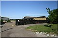
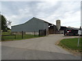
West Farm, Lawshall
A dairy farm, fairly rare in Suffolk, where most farm animals are sheep.
Image: © Bob Jones
Taken: 3 Jul 2006
0.06 miles
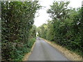
6
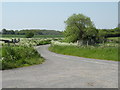
Country Road
Country road near to Brockley, Suffolk.
Image: © Keith Evans
Taken: 10 Oct 2010
0.17 miles