IMAGES TAKEN NEAR TO
Hartest, BURY ST. EDMUNDS, IP29 4EE
Introduction
This page details the photographs taken nearby to IP29 4EE by members of the Geograph project.
The Geograph project started in 2005 with the aim of publishing, organising and preserving representative images for every square kilometre of Great Britain, Ireland and the Isle of Man.

There are currently over 7.5m images from over14,400 individuals and you can help contribute to the project by visiting https://www.geograph.org.uk
Image Map
Images are licensed for reuse under creativecommons.org/licenses/by-sa/2.0
Notes
- Clicking on the map will re-center to the selected point.
- The higher the marker number, the further away the image location is from the centre of the postcode.
Image Listing (3 Images Found)
Images are licensed for reuse under creativecommons.org/licenses/by-sa/2.0
Image
Details
Distance
1
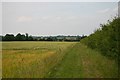
Byway to Tuffields Road
This byway is currently closed to vehicular traffic due to its condition.
Image: © Bob Jones
Taken: 4 Jul 2006
0.15 miles
2
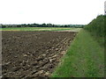
Ploughed Field
Ploughed field and footpath near to Brockley, Suffolk.
Image: © Keith Evans
Taken: 7 Sep 2011
0.19 miles
3
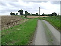
Country Road
Country road near to Hartest, Suffolk.
Image: © Keith Evans
Taken: 7 Sep 2011
0.23 miles