IMAGES TAKEN NEAR TO
Hartest, BURY ST. EDMUNDS, IP29 4EB
Introduction
This page details the photographs taken nearby to IP29 4EB by members of the Geograph project.
The Geograph project started in 2005 with the aim of publishing, organising and preserving representative images for every square kilometre of Great Britain, Ireland and the Isle of Man.

There are currently over 7.5m images from over14,400 individuals and you can help contribute to the project by visiting https://www.geograph.org.uk
Image Map
Images are licensed for reuse under creativecommons.org/licenses/by-sa/2.0
Notes
- Clicking on the map will re-center to the selected point.
- The higher the marker number, the further away the image location is from the centre of the postcode.
Image Listing (34 Images Found)
Images are licensed for reuse under creativecommons.org/licenses/by-sa/2.0
Image
Details
Distance
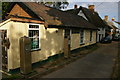
1
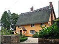
The Hatch
Cottage called The Hatch Cross Green, Suffolk.
Image: © Keith Evans
Taken: 7 Sep 2011
0.13 miles
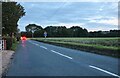
3
View from Somerton Road rising west from Hartest village
Scattered houses with Cross Green beyond.
Image: © Andrew Hill
Taken: 20 Sep 2008
0.16 miles
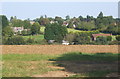
4

View west from Lawshall Road
North of Hartest, looking towards Cross Green.
Image: © Peter Barr
Taken: 11 Sep 2010
0.16 miles
6
Hartest Garage
Old fashioned petrol pumps in a former road-side garage.
Image: © Peter Barr
Taken: 11 Sep 2010
0.18 miles
7
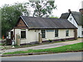
Hartest Garage
Hartest garage Hartest, Suffolk.
Image: © Keith Evans
Taken: 7 Sep 2011
0.18 miles
8
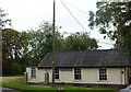
Hartest Village Institute and war memorial
Image: © David Ayrton
Taken: 23 Sep 2007
0.19 miles
10
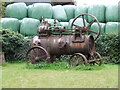
Old Engine
Old steam engine at Hartest, Suffolk.
Image: © Keith Evans
Taken: 7 Sep 2011
0.20 miles