IMAGES TAKEN NEAR TO
The Green, BURY ST. EDMUNDS, IP29 4DH
Introduction
This page details the photographs taken nearby to The Green, IP29 4DH by members of the Geograph project.
The Geograph project started in 2005 with the aim of publishing, organising and preserving representative images for every square kilometre of Great Britain, Ireland and the Isle of Man.

There are currently over 7.5m images from over14,400 individuals and you can help contribute to the project by visiting https://www.geograph.org.uk
Image Map
Images are licensed for reuse under creativecommons.org/licenses/by-sa/2.0
Notes
- Clicking on the map will re-center to the selected point.
- The higher the marker number, the further away the image location is from the centre of the postcode.
Image Listing (109 Images Found)
Images are licensed for reuse under creativecommons.org/licenses/by-sa/2.0
Image
Details
Distance
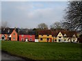
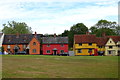
1
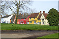
Hartest: the east side of the green
The colourful and often-photographed row of old Grade II listed houses facing the green.
Image: © John Sutton
Taken: 23 Jun 2021
0.01 miles
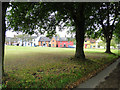
3
Bright cottages lining the green at Hartest
Image: © Andrew Hill
Taken: 20 Sep 2008
0.02 miles
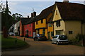
4
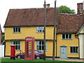
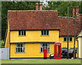
Red Boxes And Cottages
Post box telephone box and cottages at Hartest, Suffolk.
Image: © Keith Evans
Taken: 7 Sep 2011
0.02 miles
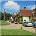
8
Postbox and telephone box, Hartest
Outside the former Post Office.
Postbox No. IP29 2129.
Image: © JThomas
Taken: 31 Aug 2019
0.02 miles
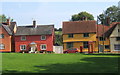
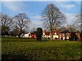
9
Houses on green, Hartest
An assembly of grade II listed buildings.
Image: © Robin Webster
Taken: 7 Mar 2020
0.02 miles