IMAGES TAKEN NEAR TO
Depden, BURY ST. EDMUNDS, IP29 4BZ
Introduction
This page details the photographs taken nearby to IP29 4BZ by members of the Geograph project.
The Geograph project started in 2005 with the aim of publishing, organising and preserving representative images for every square kilometre of Great Britain, Ireland and the Isle of Man.

There are currently over 7.5m images from over14,400 individuals and you can help contribute to the project by visiting https://www.geograph.org.uk
Image Map
Images are licensed for reuse under creativecommons.org/licenses/by-sa/2.0
Notes
- Clicking on the map will re-center to the selected point.
- The higher the marker number, the further away the image location is from the centre of the postcode.
Image Listing (8 Images Found)
Images are licensed for reuse under creativecommons.org/licenses/by-sa/2.0
Image
Details
Distance
1
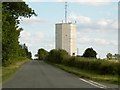
Water tower by the Hargrave to Wickhambrook road
Image: © Robert Edwards
Taken: 13 Jul 2009
0.14 miles

3
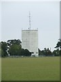
White water tower
Water tower near to Depden Green, Suffolk.
Image: © Keith Evans
Taken: 4 Oct 2008
0.14 miles
4
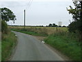
Country road and water tower
Country road and water tower looking east near to Depden Green, Suffolk.
Image: © Keith Evans
Taken: 4 Oct 2008
0.14 miles
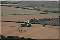


8

Bridleway to Chevington
Looking north from Depden Green.
Image: © Bob Jones
Taken: 16 Jun 2006
0.24 miles