IMAGES TAKEN NEAR TO
Depden, BURY ST. EDMUNDS, IP29 4BT
Introduction
This page details the photographs taken nearby to IP29 4BT by members of the Geograph project.
The Geograph project started in 2005 with the aim of publishing, organising and preserving representative images for every square kilometre of Great Britain, Ireland and the Isle of Man.

There are currently over 7.5m images from over14,400 individuals and you can help contribute to the project by visiting https://www.geograph.org.uk
Image Map
Images are licensed for reuse under creativecommons.org/licenses/by-sa/2.0
Notes
- Clicking on the map will re-center to the selected point.
- The higher the marker number, the further away the image location is from the centre of the postcode.
Image Listing (4 Images Found)
Images are licensed for reuse under creativecommons.org/licenses/by-sa/2.0
Image
Details
Distance
1
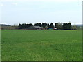
Coblands Farm
Coblands Farm as seen from the lay-by on the A.143 near to Clopton Green, Suffolk.
Image: © Keith Evans
Taken: 5 Apr 2009
0.04 miles
2
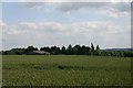
Coblands Farm, near Depden
Viewed from the lay-by on the A143.
Image: © Bob Jones
Taken: 23 Jun 2006
0.05 miles
3
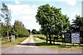
Entrance to Coblands Farm
Antiques are sold and furniture repaired at this farm.
Image: © Bob Jones
Taken: 23 Jun 2006
0.13 miles
4
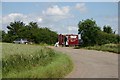
Big Al's caff off the A143
A large bend in the road, now by-passed, serves as a lay-by, where 'Big Al' does a roaring trade.
Image: © Bob Jones
Taken: 23 Jun 2006
0.16 miles