IMAGES TAKEN NEAR TO
Bath Street, IPSWICH, IP2 8SD
Introduction
This page details the photographs taken nearby to Bath Street, IP2 8SD by members of the Geograph project.
The Geograph project started in 2005 with the aim of publishing, organising and preserving representative images for every square kilometre of Great Britain, Ireland and the Isle of Man.

There are currently over 7.5m images from over14,400 individuals and you can help contribute to the project by visiting https://www.geograph.org.uk
Image Map
Images are licensed for reuse under creativecommons.org/licenses/by-sa/2.0
Notes
- Clicking on the map will re-center to the selected point.
- The higher the marker number, the further away the image location is from the centre of the postcode.
Image Listing (157 Images Found)
Images are licensed for reuse under creativecommons.org/licenses/by-sa/2.0
Image
Details
Distance
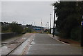
1
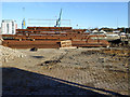
Stack of steel, Griffin Wharf, Ipswich
Looking through a gap of hoardings along the public road here. There seemed to be some sort of improvement to the quayside flood resistance going on, so this might be to do with that. In the immediate foreground is one of the rails of the Griffin Wharf branch line, getting near its present day end, off to the left. Its last traffic was to an aggregates terminal some good way off to the right, when this part may have been used for backing trains into it, but this traffic may have ceased now.
Image: © Robin Webster
Taken: 19 Nov 2017
0.03 miles
2
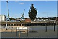
New urban landscaping at New Cut West
The New Cut was opened in 1842, forming a river channel around the wet dock creating the largest enclosed dock in the UK at the time. In the foreground is the newly-landscaped Waterfront West Bank, created as part of the construction of a new tidal barrier across the New Cut. The Griffin Ferry used to run across the New Cut at this point until the mid-20th Century.
Image: © Simon Mortimer
Taken: 10 Sep 2020
0.03 miles
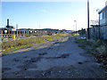
3
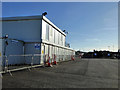
Car park and site cabins, Griffin Wharf, Ipswich
There was quite a lot of redevelopments going on or had been going on in the general area, but it was not clear which these applied to. Possibly to do with improvement to the quay flood defences, which looked as if it might be going on.
Image: © Robin Webster
Taken: 19 Nov 2017
0.04 miles
6
Griffin Wharf, Ipswich
The river bank is over to the left. The grassy strip hides the tracks of the Griffin Wharf branch line, whose residual traffic is or was to an aggregates wharf in the distance. The tarmac ought to be a dead-end public byway, according to maps, but it is blanked off with hoarding gates at the camera position. The view is through the padlock aperture.
Image: © Robin Webster
Taken: 19 Nov 2017
0.04 miles
7
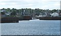
The New Cut, Ipswich
Looking upstream [locally north]. The New Cut is the realigned route of the River Gipping, created when the floating harbour was built alongside. The 'Ip' in Ipswich comes from 'Gipping'.
Image: © Christine Johnstone
Taken: 12 Jul 2017
0.05 miles

9
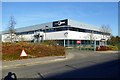
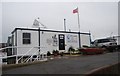
IP-City Centre, Ipswich
According to their website, "IP-City Centre is a modern business and conference centre, with high specification office suites, flexible conference facilities and meeting rooms to accommodate up to 100 people".
Image: © Robin Webster
Taken: 19 Nov 2017
0.06 miles
10

Hook Of Crane
Close up of crane hook Ipswich dock Suffolk for view of crane see http://www.geograph.org.uk/photo/373782
Image: © Keith Evans
Taken: 24 Feb 2007
0.06 miles