IMAGES TAKEN NEAR TO
Montgomery Road, IPSWICH, IP2 8QF
Introduction
This page details the photographs taken nearby to Montgomery Road, IP2 8QF by members of the Geograph project.
The Geograph project started in 2005 with the aim of publishing, organising and preserving representative images for every square kilometre of Great Britain, Ireland and the Isle of Man.

There are currently over 7.5m images from over14,400 individuals and you can help contribute to the project by visiting https://www.geograph.org.uk
Image Map (Loading...)


Getting Data...Please wait
Leaflet Map data © OpenStreetMap
Images are licensed for reuse under creativecommons.org/licenses/by-sa/2.0
Notes
- Clicking on the map will re-center to the selected point.
- The higher the marker number, the further away the image location is from the centre of the postcode.
Image Listing (25 Images Found)
Images are licensed for reuse under creativecommons.org/licenses/by-sa/2.0
Image
Details
Distance
1

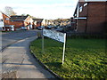
Montgomery Road
The view of Montgomery Road at the corner with Tenby Road, the road to the right at the lamppost.
Image: © Sandy Gemmill
Taken: 15 Nov 2023
0.17 miles
2
Lanercost Way
Lanercost Way, Ipswich. Presumably named after Lanercost, Cumbria http://www.geograph.org.uk/gridref/NY5563 http://en.wikipedia.org/wiki/Lanercost.
Image: © Hamish Griffin
Taken: 21 Feb 2014
0.19 miles
3

Halifax Primary School, Ipswich
The school building was designed by celebrated Ipswich architect Birkin Haward (1912-2002) using an innovative open plan design. It was opened in 1971 by the then Secretary of State for Education, Margaret Thatcher.
Image: © Simon Mortimer
Taken: 10 Sep 2020
0.19 miles

5

Stoke Green Baptist Church
The church building dates back to 1954 when the estate of Maiden Hall was developed for housing. The church itself has a longer history and is the second oldest baptist church in Suffolk. From 1775 it occupied a building on Wherstead Road where Peppercorn Way is now, although the congregation had been meeting for a few decades before that, originally in Woolverstone.
Image: © Simon Mortimer
Taken: 10 Sep 2020
0.20 miles
6
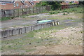
Shopping Trolley Storage area on Waste Ground
Near Asda Stoke Park Superstore
Image: © Geographer
Taken: 30 May 2018
0.21 miles
7
Shopping Trolley Storage area on Waste Ground
Near Asda Stoke Park Superstore
Image: © Geographer
Taken: 30 May 2018
0.21 miles
8

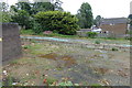
Footpath leading to Conway Close
The footpath to the west of the Community Garden.
Image: © Sandy Gemmill
Taken: 15 Nov 2023
0.21 miles
9
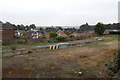
Houses on Malmesbury Close
Near Asda Stoke Park Superstore
Image: © Geographer
Taken: 30 May 2018
0.22 miles
10

Welcome to Asda Stoke Park Superstore
Off Stoke Park Drive
https://storelocator.asda.com/store/stoke-park
Image: © Geographer
Taken: 30 May 2018
0.23 miles