IMAGES TAKEN NEAR TO
Conway Close, IPSWICH, IP2 8PT
Introduction
This page details the photographs taken nearby to Conway Close, IP2 8PT by members of the Geograph project.
The Geograph project started in 2005 with the aim of publishing, organising and preserving representative images for every square kilometre of Great Britain, Ireland and the Isle of Man.

There are currently over 7.5m images from over14,400 individuals and you can help contribute to the project by visiting https://www.geograph.org.uk
Image Map
Images are licensed for reuse under creativecommons.org/licenses/by-sa/2.0
Notes
- Clicking on the map will re-center to the selected point.
- The higher the marker number, the further away the image location is from the centre of the postcode.
Image Listing (21 Images Found)
Images are licensed for reuse under creativecommons.org/licenses/by-sa/2.0
Image
Details
Distance
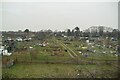
2
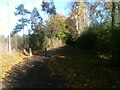
Footpath leading to Conway Close
The footpath to the west of the Community Garden.
Image: © Sandy Gemmill
Taken: 15 Nov 2023
0.10 miles
3
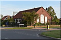
Stoke Green Baptist Church
The church building dates back to 1954 when the estate of Maiden Hall was developed for housing. The church itself has a longer history and is the second oldest baptist church in Suffolk. From 1775 it occupied a building on Wherstead Road where Peppercorn Way is now, although the congregation had been meeting for a few decades before that, originally in Woolverstone.
Image: © Simon Mortimer
Taken: 10 Sep 2020
0.10 miles
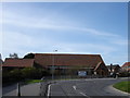
4
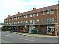
Estate Shops
A small row of shops on Maidenhall Approach Ipswich Suffolk.
Image: © Keith Evans
Taken: 27 Nov 2006
0.10 miles
9

Backs of houses on Wherstead Road, Ipswich, from the railway
Beyond the houses on the right, the Orwell Bridge carrying the A14; in the centre, a tall pylon carrying electricity over the river.
Image: © Christopher Hilton
Taken: 14 Nov 2018
0.19 miles
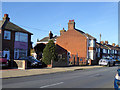
10
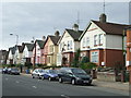
Whearstead Road
Houses along Wherstead Road Ipswich, Suffolk.
Image: © Keith Evans
Taken: 29 Sep 2008
0.20 miles