IMAGES TAKEN NEAR TO
The Strand, IPSWICH, IP2 8NL
Introduction
This page details the photographs taken nearby to The Strand, IP2 8NL by members of the Geograph project.
The Geograph project started in 2005 with the aim of publishing, organising and preserving representative images for every square kilometre of Great Britain, Ireland and the Isle of Man.

There are currently over 7.5m images from over14,400 individuals and you can help contribute to the project by visiting https://www.geograph.org.uk
Image Map
Images are licensed for reuse under creativecommons.org/licenses/by-sa/2.0
Notes
- Clicking on the map will re-center to the selected point.
- The higher the marker number, the further away the image location is from the centre of the postcode.
Image Listing (48 Images Found)
Images are licensed for reuse under creativecommons.org/licenses/by-sa/2.0
Image
Details
Distance
1
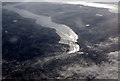
Ipswich and the Orwell Bridge from the air
The cloud in the lower right corner was the start of a mass that covered most of the rest of the country. Viewed from a Stansted bound flight from Prague.
Best viewed in large size.
Image: © Thomas Nugent
Taken: 6 Feb 2010
0.12 miles
2
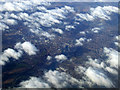
Ipswich from the air
Surrounded by clouds.
Image: © Thomas Nugent
Taken: 27 Feb 2013
0.12 miles
3
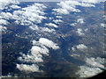
Ipswich from the air
Viewed from a Luton bound flight from Prague.
Image: © Thomas Nugent
Taken: 27 Feb 2013
0.12 miles
4
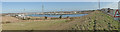
North to east panorama of the River Orwell and the bridge
Image: © Adrian S Pye
Taken: 10 Mar 2015
0.14 miles
5
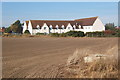
Premier Inn, shown as Motel on the map
Next to the "Oyster Reach" Beefeater restaurant. Seen from the path behind the houses running parallel to the B1456.
Image: © Andrew Hill
Taken: 11 Oct 2008
0.15 miles
6
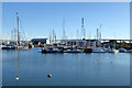
Fox's Marina
In the short Ostrich or Bourne Bridge Creek, just off the main Orwell.
Image: © Robin Webster
Taken: 19 Nov 2017
0.17 miles
7
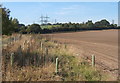
Fields north of the A14 at the west end of the Orwell Bridge
Lines of pylons traverse a line between the A14/A12 and the southern edge of Ipswich.
Image: © Andrew Hill
Taken: 11 Oct 2008
0.17 miles
8
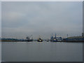
Dredging at the entrance of Ipswich Docks
Image: © jax horswill
Taken: 28 Jan 2008
0.18 miles
9
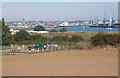
Field overlooking the river towards Ipswich
Image: © Andrew Hill
Taken: 11 Oct 2008
0.18 miles
10
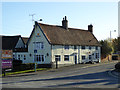
Beefeater restaurant, near Bourne Bridge, Ipswich
A former pub, that seems to have been divested of any specific name or reference to alcohol, and now is indicated to be just a restaurant. Behind is an associated Premier Inn. The old pub part is a grade II listed building, 16th/17th centuries with many later additions and alterations. It was originally The Ostrich, which name lives on in that of the nearby creek.
Image: © Robin Webster
Taken: 19 Nov 2017
0.18 miles