IMAGES TAKEN NEAR TO
Wherstead Road, IPSWICH, IP2 8LD
Introduction
This page details the photographs taken nearby to Wherstead Road, IP2 8LD by members of the Geograph project.
The Geograph project started in 2005 with the aim of publishing, organising and preserving representative images for every square kilometre of Great Britain, Ireland and the Isle of Man.

There are currently over 7.5m images from over14,400 individuals and you can help contribute to the project by visiting https://www.geograph.org.uk
Image Map (Loading...)


Getting Data...Please wait
Leaflet Map data © OpenStreetMap
Images are licensed for reuse under creativecommons.org/licenses/by-sa/2.0
Notes
- Clicking on the map will re-center to the selected point.
- The higher the marker number, the further away the image location is from the centre of the postcode.
Image Listing (41 Images Found)
Images are licensed for reuse under creativecommons.org/licenses/by-sa/2.0
Image
Details
Distance
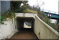
1
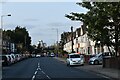
Houses on Wherstead Road, Ipswich
Looking north towards the Griffin Wharf Branch railway bridge. The houses on the right were built in the 1930s in the grounds of Nova Scotia House and had gardens running down to the river Orwell until the construction of the West Bank Terminal in the early 1970s.
Image: © Simon Mortimer
Taken: 10 Sep 2020
0.01 miles
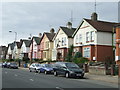
2
Houses on Wherstead Road
Looking at old maps, these seem to have been built in the 1930s
Image: © Keith Edkins
Taken: 4 Aug 2018
0.02 miles
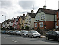
3
Whearstead Road
Houses along Wherstead Road Ipswich, Suffolk.
Image: © Keith Evans
Taken: 29 Sep 2008
0.02 miles
6
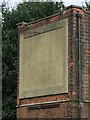
Detail of Halifax Quay Underground Station ?
A close up of what must have been an illuminated sign on the two storey control block of Halifax Quay station, one of the first stations on the spoof Ipswich underground system to be built Wherstead Road Ipswich, Suffolk for more info on Ipswich underground system see this fascinating web site http://www.ipswich-underground.co.uk/ for full view see http://www.geograph.org.uk/photo/986360
Image: © Keith Evans
Taken: 29 Sep 2008
0.06 miles
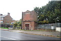
7
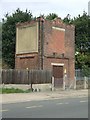
Part of Halifax Quay Underground Station ?
The two storey control block is all that survives of Halifax Quay station. One of the first stations on the spoof Ipswich underground system to be built. Wherstead Road Ipswich, Suffolk.
Image: © Keith Evans
Taken: 29 Sep 2008
0.06 miles
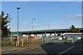
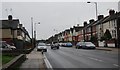
10
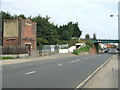
Whearstead Road underground station and railway bridge ?
The site of the spoof underground station and railway bridge in Wherstead Road. The two storey control block is all that survives of Halifax Quay station. One of the first stations on the Ipswich underground system to be built? Wherstead Road Ipswich, Suffolk for more info on Ipswich underground system see this fascinating web site http://www.ipswich-underground.co.uk/
Image: © Keith Evans
Taken: 29 Sep 2008
0.08 miles