
IMAGES TAKEN NEAR TO
Station Street, IPSWICH, IP2 8EA
Introduction
This page details the photographs taken nearby to Station Street, IP2 8EA by members of the Geograph project.
The Geograph project started in 2005 with the aim of publishing, organising and preserving representative images for every square kilometre of Great Britain, Ireland and the Isle of Man.

There are currently over 7.5m images from over14,400 individuals and you can help contribute to the project by visiting https://www.geograph.org.uk
Image Map
Images are licensed for reuse under creativecommons.org/licenses/by-sa/2.0
Notes
- Clicking on the map will re-center to the selected point.
- The higher the marker number, the further away the image location is from the centre of the postcode.
Image Listing (115 Images Found)
Images are licensed for reuse under creativecommons.org/licenses/by-sa/2.0
Image
Details
Distance
1
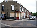
Disused pub in Croft Street
The Eur, disused Public House on the junction of Croft Street and Webb Street in Stoke, Ipswich.
Image: © Trevor Alder
Taken: 14 May 2007
0.02 miles
2

National Cycle Route 1
Looking west on Station Street.
Image: © JThomas
Taken: 12 May 2023
0.02 miles
3
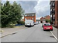
Ipswich 1st railway station (site), Suffolk
Opened in 1846 by the Eastern Union Railway, later part of the Great Eastern Railway, as the terminus of the line from Colchester, this station closed to passengers in 1860 when the current Ipswich station opened. It was informally known as "Croft Street" or "Stoke Hill" station. For many years after, this was the site of an engine shed and wagon repair shop. The area has now been completely redeveloped for housing.
View south on Bruff Road from approximately the site of the buffers. Old maps show there was a small station building immediately to the right, set back off Croft Street. A terminus just off the main line would have been highly inconvenient operationally as trains had to reverse in and out of this station until the current through station was built.
No trace remains, except in the road name. Peter Bruff was the resident engineer of the EUR at the time of opening.
Image: © Nigel Thompson
Taken: 28 Jul 2021
0.08 miles

5
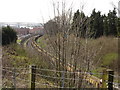
Railway line, Stoke Park
With a long line of trucks full of sand waiting for permission to pass through Ipswich station.
Image: © Oxymoron
Taken: 5 Apr 2009
0.09 miles


10
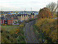
View south-east from above Ipswich Tunnel
Looking towards Orwell Bridge, built high to clear shipping navigating to Ipswich Docks.
Image: © Robin Webster
Taken: 19 Nov 2017
0.12 miles