IMAGES TAKEN NEAR TO
Kenyon Street, IPSWICH, IP2 8DJ
Introduction
This page details the photographs taken nearby to Kenyon Street, IP2 8DJ by members of the Geograph project.
The Geograph project started in 2005 with the aim of publishing, organising and preserving representative images for every square kilometre of Great Britain, Ireland and the Isle of Man.

There are currently over 7.5m images from over14,400 individuals and you can help contribute to the project by visiting https://www.geograph.org.uk
Image Map
Images are licensed for reuse under creativecommons.org/licenses/by-sa/2.0
Notes
- Clicking on the map will re-center to the selected point.
- The higher the marker number, the further away the image location is from the centre of the postcode.
Image Listing (168 Images Found)
Images are licensed for reuse under creativecommons.org/licenses/by-sa/2.0
Image
Details
Distance
1

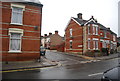
National Cycle Route 1
Looking west on Station Street.
Image: © JThomas
Taken: 12 May 2023
0.05 miles

3
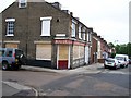
Disused pub in Croft Street
The Eur, disused Public House on the junction of Croft Street and Webb Street in Stoke, Ipswich.
Image: © Trevor Alder
Taken: 14 May 2007
0.07 miles


10
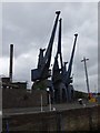
Ipswich harbour Cranes
Old cranes probable not in use any more. Nice that these old things are kept in good order for future generations.
Image: © Nigel Richardson
Taken: 25 Jun 2005
0.09 miles