IMAGES TAKEN NEAR TO
Belstead Road, IPSWICH, IP2 8AU
Introduction
This page details the photographs taken nearby to Belstead Road, IP2 8AU by members of the Geograph project.
The Geograph project started in 2005 with the aim of publishing, organising and preserving representative images for every square kilometre of Great Britain, Ireland and the Isle of Man.

There are currently over 7.5m images from over14,400 individuals and you can help contribute to the project by visiting https://www.geograph.org.uk
Image Map
Images are licensed for reuse under creativecommons.org/licenses/by-sa/2.0
Notes
- Clicking on the map will re-center to the selected point.
- The higher the marker number, the further away the image location is from the centre of the postcode.
Image Listing (325 Images Found)
Images are licensed for reuse under creativecommons.org/licenses/by-sa/2.0
Image
Details
Distance
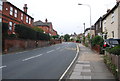
2
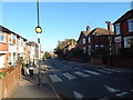
Zebra crossing, Belstead Road
Just after the Luther Road junction, looking towards the town centre.
Image: © Hamish Griffin
Taken: 27 Oct 2014
0.02 miles
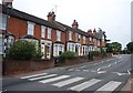
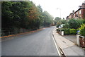
3
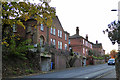
Houses on Belstead Road, Ipswich
Coping with the contours of Stoke Hill.
Image: © Robin Webster
Taken: 19 Nov 2017
0.02 miles
8
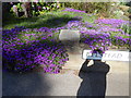
Purple flowers on Belstead Road
Located opposite the Luther Road/Philip Road junction.
Image: © Hamish Griffin
Taken: 21 Mar 2014
0.05 miles
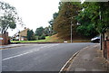
9
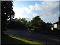
Willoughby Road junction
From the green area above. Willoughby Road goes towards the railway station.
Image: © Hamish Griffin
Taken: 13 May 2014
0.05 miles
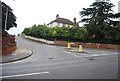
10
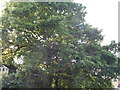
Oak Tree above Belstead Road
Belstead Road is to the right.
Image: © Hamish Griffin
Taken: 13 May 2014
0.06 miles