IMAGES TAKEN NEAR TO
Burrell Road, IPSWICH, IP2 8AH
Introduction
This page details the photographs taken nearby to Burrell Road, IP2 8AH by members of the Geograph project.
The Geograph project started in 2005 with the aim of publishing, organising and preserving representative images for every square kilometre of Great Britain, Ireland and the Isle of Man.

There are currently over 7.5m images from over14,400 individuals and you can help contribute to the project by visiting https://www.geograph.org.uk
Image Map
Images are licensed for reuse under creativecommons.org/licenses/by-sa/2.0
Notes
- Clicking on the map will re-center to the selected point.
- The higher the marker number, the further away the image location is from the centre of the postcode.
Image Listing (396 Images Found)
Images are licensed for reuse under creativecommons.org/licenses/by-sa/2.0
Image
Details
Distance
1
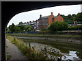
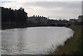
Houses by the Gipping
Viewed from under the Princes Street bridge.
Image: © Andrew Hill
Taken: 31 Aug 2009
0.02 miles
2
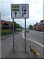
A12 and A14 straight on sign on Burrell Road (B1073)
Parking and other right.
Image: © Hamish Griffin
Taken: 26 May 2014
0.02 miles
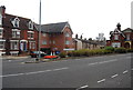
3
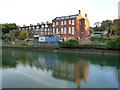
Housing on Burrell Road, Ipswich
Looking across the River Orwell.
Image: © Robin Webster
Taken: 19 Nov 2017
0.02 miles
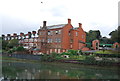
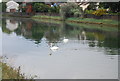
4
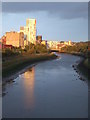
High tide, Ipswich
High tide on the River Gipping, photographed from the Princes Street bridge in Ipswich
Image: © Malc McDonald
Taken: 25 Sep 2010
0.02 miles
5
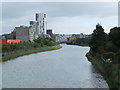
Low tide, Ipswich
Low tide on the River Gipping, photographed from the Princes Street bridge in Ipswich
Image: © Malc McDonald
Taken: 25 Sep 2010
0.02 miles