IMAGES TAKEN NEAR TO
Green Lane, BURY ST. EDMUNDS, IP28 8ZB
Introduction
This page details the photographs taken nearby to Green Lane, IP28 8ZB by members of the Geograph project.
The Geograph project started in 2005 with the aim of publishing, organising and preserving representative images for every square kilometre of Great Britain, Ireland and the Isle of Man.

There are currently over 7.5m images from over14,400 individuals and you can help contribute to the project by visiting https://www.geograph.org.uk
Image Map
Images are licensed for reuse under creativecommons.org/licenses/by-sa/2.0
Notes
- Clicking on the map will re-center to the selected point.
- The higher the marker number, the further away the image location is from the centre of the postcode.
Image Listing (3 Images Found)
Images are licensed for reuse under creativecommons.org/licenses/by-sa/2.0
Image
Details
Distance
1
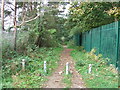
Green Lane
Green Lane at Red Lodge, Suffolk.
Image: © Keith Evans
Taken: 19 Oct 2016
0.03 miles
2
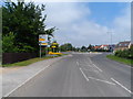
Roundabout in new housing development
The labels on the signpost have been covered up
Image: © Bikeboy
Taken: 31 May 2013
0.20 miles
3
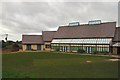
Red Lodge Millennium Centre
The village of Red Lodge is entirely new, having been created in the past fifty years. Its location, on Redlodge Heath, gave it its name. The village is growing, but away from the A11 which passes nearby. The Millennium Centre was built with lottery funding. See http://www.rlmcsuffolk.co.uk/
Image: © Bob Jones
Taken: 31 Oct 2006
0.23 miles