IMAGES TAKEN NEAR TO
Cornflower Close, BURY ST. EDMUNDS, IP28 8WA
Introduction
This page details the photographs taken nearby to Cornflower Close, IP28 8WA by members of the Geograph project.
The Geograph project started in 2005 with the aim of publishing, organising and preserving representative images for every square kilometre of Great Britain, Ireland and the Isle of Man.

There are currently over 7.5m images from over14,400 individuals and you can help contribute to the project by visiting https://www.geograph.org.uk
Image Map
Images are licensed for reuse under creativecommons.org/licenses/by-sa/2.0
Notes
- Clicking on the map will re-center to the selected point.
- The higher the marker number, the further away the image location is from the centre of the postcode.
Image Listing (9 Images Found)
Images are licensed for reuse under creativecommons.org/licenses/by-sa/2.0
Image
Details
Distance
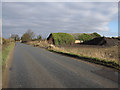
1
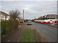
West Row
New housing being built on Pott Hall Road.
Image: © Hugh Venables
Taken: 17 Jan 2010
0.03 miles
4
Pott Hall Road
Telephone box under the power lines. Looking away from West Row.
Image: © Hugh Venables
Taken: 13 Dec 2009
0.09 miles
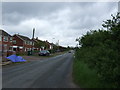
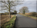
5
Pott Hall Road
Looking away from West Row.
Image: © Hugh Venables
Taken: 17 Jan 2010
0.12 miles
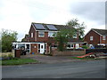
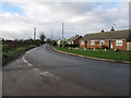
6
Chapel Road
Junction with Pott Hall Road.
Image: © Hugh Venables
Taken: 17 Jan 2010
0.21 miles
7
Bargate Road, West Row
South-east corner of the village.
Image: © Hugh Venables
Taken: 13 Dec 2009
0.24 miles
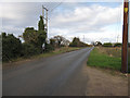
8
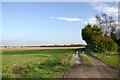
Farm track at West Row
This council-owned farm track leads east from the village of West Row.
Image: © Bob Jones
Taken: 4 Dec 2006
0.24 miles
9
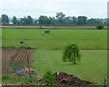
Are you looking at me? Oh deer.
Only yards from RAF Mildenhall and all the human activity and noise that it generates, this deer seemed happy to stand out in a field with nowhere to hide. The flatness of the land indicates that this is the start of the Fens.
Image: © John Goldsmith
Taken: 15 May 2009
0.25 miles