IMAGES TAKEN NEAR TO
Holly Close, BURY ST. EDMUNDS, IP28 8UX
Introduction
This page details the photographs taken nearby to Holly Close, IP28 8UX by members of the Geograph project.
The Geograph project started in 2005 with the aim of publishing, organising and preserving representative images for every square kilometre of Great Britain, Ireland and the Isle of Man.

There are currently over 7.5m images from over14,400 individuals and you can help contribute to the project by visiting https://www.geograph.org.uk
Image Map
Images are licensed for reuse under creativecommons.org/licenses/by-sa/2.0
Notes
- Clicking on the map will re-center to the selected point.
- The higher the marker number, the further away the image location is from the centre of the postcode.
Image Listing (6 Images Found)
Images are licensed for reuse under creativecommons.org/licenses/by-sa/2.0
Image
Details
Distance
1
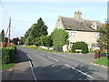
The Street Holywell Row
Looking along The Street with Holywell Farm on the right at Holywell Row, Suffolk.
Image: © Keith Evans
Taken: 3 Oct 2013
0.19 miles
2
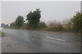
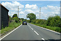
Heavy downpour on the A1101, Holywell Row
Mildenhall airbase is on the left which the road runs alongside.
Image: © David Howard
Taken: 19 Sep 2021
0.21 miles
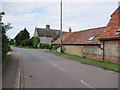
4
Holywell Farm, Holywell Row, near Mildenhall
Holywell Row is just one of a half dozen hamlets surrounding Mildenhall
Image: © Adrian S Pye
Taken: 26 May 2015
0.22 miles
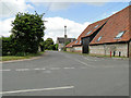
5
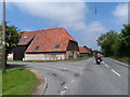
Junction of Mildenhall Road and The Street, Holywell Row
Attractively converted buildings and German Bikers on Sat Navs (GBSN's)
Image: © Bikeboy
Taken: 31 May 2013
0.23 miles
6
Eriswell Road heading north
Towards Lakenheath.
Image: © Robin Webster
Taken: 12 Jul 2020
0.25 miles