IMAGES TAKEN NEAR TO
Freckenham Road, BURY ST. EDMUNDS, IP28 8SN
Introduction
This page details the photographs taken nearby to Freckenham Road, IP28 8SN by members of the Geograph project.
The Geograph project started in 2005 with the aim of publishing, organising and preserving representative images for every square kilometre of Great Britain, Ireland and the Isle of Man.

There are currently over 7.5m images from over14,400 individuals and you can help contribute to the project by visiting https://www.geograph.org.uk
Image Map
Images are licensed for reuse under creativecommons.org/licenses/by-sa/2.0
Notes
- Clicking on the map will re-center to the selected point.
- The higher the marker number, the further away the image location is from the centre of the postcode.
Image Listing (6 Images Found)
Images are licensed for reuse under creativecommons.org/licenses/by-sa/2.0
Image
Details
Distance
1
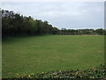
Grazing and hedgerow near Worlington
Off Freckenham Road.
Image: © JThomas
Taken: 15 Oct 2015
0.07 miles
2
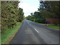
Freckenham Road (B1102)
Heading north east towards Mildenhall.
Image: © JThomas
Taken: 15 Oct 2015
0.10 miles
3
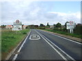
Entering Worlington
Heading north east on Freckenham Road (B1102).
Image: © JThomas
Taken: 15 Oct 2015
0.15 miles
4
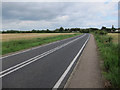
Freckenham Road
Heading towards Worlington.
Image: © Hugh Venables
Taken: 23 Jun 2012
0.18 miles
5
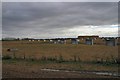
Pig farm, Worlington
This organic pig farm is situated south of the B1102, between Worlington and Freckenham.
Image: © Bob Jones
Taken: 31 Oct 2006
0.19 miles
6
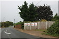
Freckenham Road, Worlington
I think the widespread NO posters were something to do with a solar farm or a rail link, those were the two issues across the area.
Image: © David Howard
Taken: 19 Sep 2021
0.23 miles