IMAGES TAKEN NEAR TO
Street Farm Close, BURY ST. EDMUNDS, IP28 8PU
Introduction
This page details the photographs taken nearby to Street Farm Close, IP28 8PU by members of the Geograph project.
The Geograph project started in 2005 with the aim of publishing, organising and preserving representative images for every square kilometre of Great Britain, Ireland and the Isle of Man.

There are currently over 7.5m images from over14,400 individuals and you can help contribute to the project by visiting https://www.geograph.org.uk
Image Map
Images are licensed for reuse under creativecommons.org/licenses/by-sa/2.0
Notes
- Clicking on the map will re-center to the selected point.
- The higher the marker number, the further away the image location is from the centre of the postcode.
Image Listing (2 Images Found)
Images are licensed for reuse under creativecommons.org/licenses/by-sa/2.0
Image
Details
Distance
1
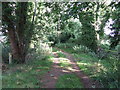
Fen Lane
This track is marked on the map as Fen Lane just north of Holywell Row, Suffolk.
Image: © Keith Evans
Taken: 3 Oct 2013
0.21 miles
2
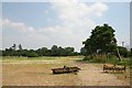
Uncultivated field at Holywell Row
Looking east from Wildmere Lane.
Image: © Bob Jones
Taken: 25 Jul 2006
0.21 miles