IMAGES TAKEN NEAR TO
Jarmans Lane, BURY ST. EDMUNDS, IP28 8NU
Introduction
This page details the photographs taken nearby to Jarmans Lane, IP28 8NU by members of the Geograph project.
The Geograph project started in 2005 with the aim of publishing, organising and preserving representative images for every square kilometre of Great Britain, Ireland and the Isle of Man.

There are currently over 7.5m images from over14,400 individuals and you can help contribute to the project by visiting https://www.geograph.org.uk
Image Map
Images are licensed for reuse under creativecommons.org/licenses/by-sa/2.0
Notes
- Clicking on the map will re-center to the selected point.
- The higher the marker number, the further away the image location is from the centre of the postcode.
Image Listing (10 Images Found)
Images are licensed for reuse under creativecommons.org/licenses/by-sa/2.0
Image
Details
Distance
1
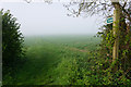
Footpath to Chapel Road
Because of the morning mist, you cannot see the other end.
Image: © Bill Boaden
Taken: 22 Apr 2015
0.13 miles


4
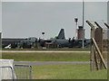
Parked Lockheed C-130 aircraft at Mildenhall
Image: © Adrian S Pye
Taken: 26 May 2015
0.18 miles
6
Fuel storage installation at Mildenhall airbase
Image: © Adrian S Pye
Taken: 26 May 2015
0.19 miles
7
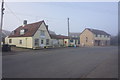
The commercial heart of West Row
Here there is the village store, a hairdresser and two takeaways.
Image: © Bill Boaden
Taken: 22 Apr 2015
0.20 miles
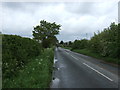
8
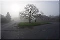
The end of The Green in West Row
Here it meets Beeches Road. It is viewed on a misty morning.
Image: © Bill Boaden
Taken: 22 Apr 2015
0.21 miles
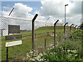
9
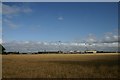
RAF Mildenhall perimeter fence
Viewed from near the camping and caravan site at Thistley Green. Various buildings within the USAF base can be seen, but their function is unknown.
Image: © Bob Jones
Taken: 7 Aug 2006
0.22 miles
10
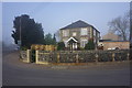
Former Wesleyan chapel in West Row
Now a residential property. The inscription says it dates from 1841.
Image: © Bill Boaden
Taken: 22 Apr 2015
0.24 miles