IMAGES TAKEN NEAR TO
Green Lane, BURY ST. EDMUNDS, IP28 8LD
Introduction
This page details the photographs taken nearby to Green Lane, IP28 8LD by members of the Geograph project.
The Geograph project started in 2005 with the aim of publishing, organising and preserving representative images for every square kilometre of Great Britain, Ireland and the Isle of Man.

There are currently over 7.5m images from over14,400 individuals and you can help contribute to the project by visiting https://www.geograph.org.uk
Image Map
Images are licensed for reuse under creativecommons.org/licenses/by-sa/2.0
Notes
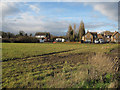
- Clicking on the map will re-center to the selected point.
- The higher the marker number, the further away the image location is from the centre of the postcode.
Image Listing (14 Images Found)
Images are licensed for reuse under creativecommons.org/licenses/by-sa/2.0
Image
Details
Distance
1
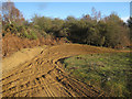
Scrambling bike tracks
On open land at Red Lodge. Looks unofficial, but fun.
Image: © Hugh Venables
Taken: 13 Dec 2009
0.14 miles
2
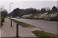
Turnpike Road, Red Lodge
Now the B1085, this was part of the A11 until Red Lodge was by-passed.
Image: © Stephen McKay
Taken: 30 Mar 2019
0.14 miles
3
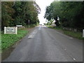
Entering Red Lodge
Entering Red Lodge, Suffolk.
Image: © Keith Evans
Taken: 19 Oct 2016
0.15 miles
4
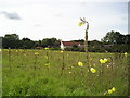
Evening Primrose in the Afternoon
This bit of scrubland had an amazing display of Evening Primrose in it. Just by the B1085 SW of the pub in Red Lodge.
Image: © mike
Taken: Unknown
0.15 miles
5
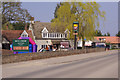
Red Lodge
This Greene King pub, in the village of the same name, styles itself as a 'steakhouse and bar' - it is certainly a quirky place with, for example, kangaroo on the menu. It is a former hunting lodge built in around 1600 and functioned for some years - when this was still the A11 - as a roadside diner.
Image: © Stephen McKay
Taken: 30 Mar 2019
0.17 miles
6
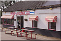
The Red Lodge Cafe
This business must have taken a hit when Red Lodge was by-passed leaving it marooned on the B1085. Nevertheless it is still here and looks cheerful enough.
Image: © Stephen McKay
Taken: 30 Mar 2019
0.18 miles
7
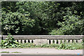
Road bridge over the River Kennett
The B1085 passes over this bridge, just before entering Red Lodge. The road was once the main road to Norwich, but has since been by-passed. The letters on the centre of the bridge, WSCC, stand for West Suffolk County Council.
Image: © Bob Jones
Taken: 24 Jun 2010
0.18 miles
8
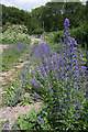
Viper's Bugloss (Echium vulgare) on the footpath
This flower is plentiful on wasteland and sandy soil, as here on the footpath between Grange Farm and the road near Red Lodge.
Image: © Bob Jones
Taken: 24 Jun 2010
0.18 miles
9
South end of Red Lodge
Houses along Turnpike Road.
Image: © Hugh Venables
Taken: 13 Dec 2009
0.19 miles
10
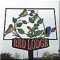
Red Lodge village sign
Red Lodge became a civil parish in 1987, having previously been part of Freckenham parish. The sign is a celebration of the natural history featuring flora and fauna of Red Lodge Heath, which is an area of acid grassland and lowland and is an SSSI, with a number of nationally rare plants and animals. https://www.geograph.org.uk/photo/6767587
Image: © Adrian S Pye
Taken: 2 Mar 2021
0.20 miles