IMAGES TAKEN NEAR TO
Elms Road, BURY ST. EDMUNDS, IP28 8JE

Introduction

This page details the photographs taken nearby to Elms Road, IP28 8JE by members of the Geograph project.

The Geograph project started in 2005 with the aim of publishing, organising and preserving representative images for every square kilometre of Great Britain, Ireland and the Isle of Man.

There are currently over 7.5m images from over14,400 individuals and you can help contribute to the project by visiting https://www.geograph.org.uk

Image Map


Images are licensed for reuse under creativecommons.org/licenses/by-sa/2.0
Notes
  • Clicking on the map will re-center to the selected point.
  • The higher the marker number, the further away the image location is from the centre of the postcode.

Image Listing (46 Images Found)

Images are licensed for reuse under creativecommons.org/licenses/by-sa/2.0
  • ...
Image
Details
Distance
1
Road to the church
From Freckenham village.
Image: © Hugh Venables Taken: 9 May 2010
0.03 miles
2
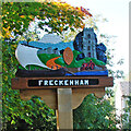
Freckenham village sign
The sign depicts a boat sailing on Lee Brook, when it was more than it is today (a tributary of the River Lark and in turn the River Kennett). It flies the saltire of St Andrew, the patron saint of the church pictured in the opposite corner. Between the two is the village's castle, destroyed by Sweyn Forkbeard of which only the motte mound remains, and never was the stone edifice depicted. In the centre is a manorial, or possibly monastic seal which dates from 12th or 13th century found in the parish. The tractor is symbolic of the agricultural nature and heritage of the village. https://www.geograph.org.uk/photo/4292704
Image: © Adrian S Pye Taken: 12 Oct 2008
0.10 miles
3
Freckenham village sign
The sign depicts a boat sailing on Lee Brook, when it was more than it is today (a tributary of the River Lark and in turn the River Kennett). It flies the saltire of St Andrew, the patron saint of the church pictured in the opposite corner. Between the two is the village's castle, destroyed by Sweyn Forkbeard of which only the motte mound remains, and never was the stone edifice depicted. In the centre is a manorial, or possibly monastic seal which dates from 12th or 13th century found in the parish. The tractor is symbolic of the agricultural nature and heritage of the village. https://www.geograph.org.uk/photo/6753171
Image: © Adrian S Pye Taken: 12 Oct 2008
0.10 miles
4
Golden Boar playground
By the pub in Freckenham.
Image: © Hugh Venables Taken: 9 May 2010
0.10 miles
5
Freckenham Village Sign
Village sign at Freckenham, Suffolk for over all view see http://www.geograph.org.uk/photo/4317323
Image: © Keith Evans Taken: 15 Jan 2015
0.10 miles
6
Village Sign
Village sign at Freckenham, Suffolk; for close up view see http://www.geograph.org.uk/photo/4317329
Image: © Keith Evans Taken: 15 Jan 2015
0.10 miles
7
Paddock in Freckenham
From the footpath between the pub and the church.
Image: © Hugh Venables Taken: 9 May 2010
0.11 miles
8
House in Freckenham
Close to St Andrew's church.
Image: © Hugh Venables Taken: 9 May 2010
0.11 miles
9
Freckenham village sign
With North Street behind.
Image: © Hugh Venables Taken: 9 May 2010
0.11 miles
10
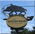
Sign for the Golden Boar at Freckenham
Image: © JThomas Taken: 15 Oct 2015
0.11 miles
  • ...