IMAGES TAKEN NEAR TO
Elderberry Road, BURY ST. EDMUNDS, IP28 8FH
Introduction
This page details the photographs taken nearby to Elderberry Road, IP28 8FH by members of the Geograph project.
The Geograph project started in 2005 with the aim of publishing, organising and preserving representative images for every square kilometre of Great Britain, Ireland and the Isle of Man.

There are currently over 7.5m images from over14,400 individuals and you can help contribute to the project by visiting https://www.geograph.org.uk
Image Map
Images are licensed for reuse under creativecommons.org/licenses/by-sa/2.0
Notes
- Clicking on the map will re-center to the selected point.
- The higher the marker number, the further away the image location is from the centre of the postcode.
Image Listing (25 Images Found)
Images are licensed for reuse under creativecommons.org/licenses/by-sa/2.0
Image
Details
Distance
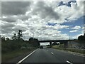
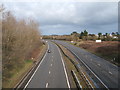
1
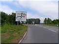
Slip road off the A11
This is the B1085 turn off to Red Lodge and Fordham.
Image: © N Chadwick
Taken: 2 Jul 2010
0.11 miles
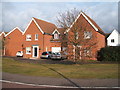
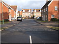
2
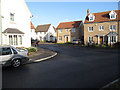
Juniper Road, Red Lodge
New housing at Red Lodge. There is more money in houses than parking places, so lots of cars are parked up on the pavement.
Image: © Hugh Venables
Taken: 17 Jan 2010
0.12 miles
4
Complicated junction of minor road with the A11
Image: © Bikeboy
Taken: 31 May 2013
0.13 miles
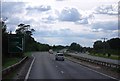
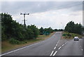
7
A11 towards London
At the slip off at Red Lodge for the B1085.
Image: © Robin Webster
Taken: 7 Mar 2020
0.15 miles
8
Juniper Road, Red Lodge
New housing off Warren Road.
Image: © JThomas
Taken: 5 Mar 2016
0.15 miles
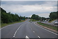
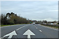
9
A11 towards Thetford
Looking north east from the bridge on the B1085.
Image: © JThomas
Taken: 5 Mar 2016
0.15 miles