IMAGES TAKEN NEAR TO
Wilde Street, BURY ST. EDMUNDS, IP28 8BT
Introduction
This page details the photographs taken nearby to Wilde Street, IP28 8BT by members of the Geograph project.
The Geograph project started in 2005 with the aim of publishing, organising and preserving representative images for every square kilometre of Great Britain, Ireland and the Isle of Man.

There are currently over 7.5m images from over14,400 individuals and you can help contribute to the project by visiting https://www.geograph.org.uk
Image Map
Images are licensed for reuse under creativecommons.org/licenses/by-sa/2.0
Notes
- Clicking on the map will re-center to the selected point.
- The higher the marker number, the further away the image location is from the centre of the postcode.
Image Listing (5 Images Found)
Images are licensed for reuse under creativecommons.org/licenses/by-sa/2.0
Image
Details
Distance
1
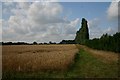
Peterfen Drove
Looking north-west from the farm on Peterfen Drove.
Image: © Bob Jones
Taken: 7 Aug 2006
0.17 miles
2
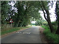
Bend Ahead
Warning signs for bend ahead on this minor road near to Wilde Street, Suffolk.
Image: © Keith Evans
Taken: 3 Oct 2013
0.17 miles
3
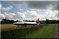
Lost?
This aircraft (someone will know the make) sits in a field next to the entrance to Ryeland Farm.
Image: © Bob Jones
Taken: 7 Aug 2006
0.17 miles
4
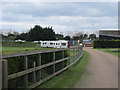
Ryeland Farm
The site of Suffolk Caravan Accessories and a caravan storage site. Permission has been granted for a caravanning and camping site. The work will involve converting a barn into a shop and constructing a toilet block.
Image: © Hugh Venables
Taken: 5 May 2012
0.22 miles
5

Preserved XG210 Hunter plane
At the entrance of Ryeland Farm.
Image: © Hugh Venables
Taken: 5 May 2012
0.23 miles