IMAGES TAKEN NEAR TO
Plumpton Avenue, BURY ST. EDMUNDS, IP28 7PA
Introduction
This page details the photographs taken nearby to Plumpton Avenue, IP28 7PA by members of the Geograph project.
The Geograph project started in 2005 with the aim of publishing, organising and preserving representative images for every square kilometre of Great Britain, Ireland and the Isle of Man.

There are currently over 7.5m images from over14,400 individuals and you can help contribute to the project by visiting https://www.geograph.org.uk
Image Map
Images are licensed for reuse under creativecommons.org/licenses/by-sa/2.0
Notes
- Clicking on the map will re-center to the selected point.
- The higher the marker number, the further away the image location is from the centre of the postcode.
Image Listing (6 Images Found)
Images are licensed for reuse under creativecommons.org/licenses/by-sa/2.0
Image
Details
Distance
3
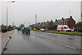
A1101 Field Road, Mildenhall
Heading north (at first) out of town towards Wisbech.
Image: © Robin Webster
Taken: 12 Jul 2020
0.17 miles
4
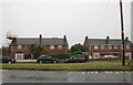
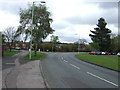
Folly Road, Mildenhall
There were two tall trees to the right of the pale house which have been cut down since 2015.
Image: © David Howard
Taken: 9 Aug 2020
0.18 miles
6

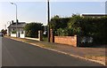
Mildenhall fire station
Mildenhall fire station, North Terrace, Mildenhall, Suffolk
Image: © Kevin Hale
Taken: 30 Jun 2010
0.24 miles