IMAGES TAKEN NEAR TO
Scott Avenue, BURY ST. EDMUNDS, IP28 7NB
Introduction
This page details the photographs taken nearby to Scott Avenue, IP28 7NB by members of the Geograph project.
The Geograph project started in 2005 with the aim of publishing, organising and preserving representative images for every square kilometre of Great Britain, Ireland and the Isle of Man.

There are currently over 7.5m images from over14,400 individuals and you can help contribute to the project by visiting https://www.geograph.org.uk
Image Map
Images are licensed for reuse under creativecommons.org/licenses/by-sa/2.0
Notes
- Clicking on the map will re-center to the selected point.
- The higher the marker number, the further away the image location is from the centre of the postcode.
Image Listing (9 Images Found)
Images are licensed for reuse under creativecommons.org/licenses/by-sa/2.0
Image
Details
Distance
1
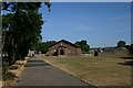
Roman Catholic church, Mildenhall
The Church of St John the Evangelist, in the heart of a modern housing estate.
Image: © Bob Jones
Taken: 24 Jul 2006
0.12 miles
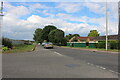
4
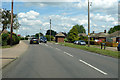
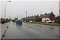
A1101 Field Road, Mildenhall
Heading north (at first) out of town towards Wisbech.
Image: © Robin Webster
Taken: 12 Jul 2020
0.21 miles
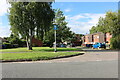
7
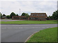
Council offices, Mildenhall
On College Heath Road.
Image: © Hugh Venables
Taken: 23 Jun 2012
0.22 miles
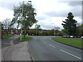
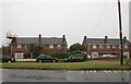
8
College Heath Road
Formerly the edge of Mildenhall but there is recent development to the right.
Image: © Hugh Venables
Taken: 23 Jun 2012
0.25 miles
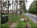
9
Field Road, Mildenhall
At the junction of Holborn Avenue
Image: © David Howard
Taken: 6 Jul 2021
0.25 miles