IMAGES TAKEN NEAR TO
Birkdale Avenue, BURY ST. EDMUNDS, IP28 7JS

Introduction

This page details the photographs taken nearby to Birkdale Avenue, IP28 7JS by members of the Geograph project.

The Geograph project started in 2005 with the aim of publishing, organising and preserving representative images for every square kilometre of Great Britain, Ireland and the Isle of Man.

There are currently over 7.5m images from over14,400 individuals and you can help contribute to the project by visiting https://www.geograph.org.uk

Image Map


Images are licensed for reuse under creativecommons.org/licenses/by-sa/2.0
Notes
  • Clicking on the map will re-center to the selected point.
  • The higher the marker number, the further away the image location is from the centre of the postcode.

Image Listing (13 Images Found)

Images are licensed for reuse under creativecommons.org/licenses/by-sa/2.0
Image
Details
Distance
1
Folly Road, Mildenhall
There were two tall trees to the right of the pale house which have been cut down since 2015.
Image: © David Howard Taken: 9 Aug 2020
0.12 miles
2
Folly Road, Mildenhall
Image: © David Howard Taken: 9 Aug 2020
0.17 miles
3
Folly Road at the junction of Junction Road
It's a road junction, twice.
Image: © David Howard Taken: 9 Aug 2020
0.19 miles
4
Queens Arms, Mildenhall
Image: © Alex McGregor Taken: 1 Mar 2011
0.19 miles
5
Houses on Field Road, Mildenhall
Image: © David Howard Taken: 19 Sep 2021
0.19 miles
6
Queensway, Mildenhall
Image: © JThomas Taken: 8 May 2012
0.20 miles
7
The Queens Arms, Mildenhall
Image: © JThomas Taken: 8 May 2012
0.20 miles
8
Field Road, Mildenhall
Image: © David Howard Taken: 19 Sep 2021
0.22 miles
9
Georgian House on King Street, Mildenhall
Image: © David Howard Taken: 18 Apr 2021
0.24 miles
10
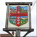
Mildenhall town sign
Down the centre, top to bottom are the crests of Edward the Confessor; Diocese of Ely, the Barton family; the North family; The Hanmer family and the Bunbury family, all having had close links with Mildenhall. In the top left quarter is the 15th century hexagonal market cross; progressing clockwise is the church of St Mary. Bottom right is an aircraft flying over open fields and ears of wheat which represent the huge airbase, open heath-land, forest and the agricultural heritage. Finally the River Lark. To each side of the name is a neolithic flint arrowhead and a flint axe, both have been found in large numbers in the area.
Image: © Adrian S Pye Taken: 22 Mar 2021
0.24 miles