IMAGES TAKEN NEAR TO
St. Annes Drive, BURY ST. EDMUNDS, IP28 7JP
Introduction
This page details the photographs taken nearby to St. Annes Drive, IP28 7JP by members of the Geograph project.
The Geograph project started in 2005 with the aim of publishing, organising and preserving representative images for every square kilometre of Great Britain, Ireland and the Isle of Man.

There are currently over 7.5m images from over14,400 individuals and you can help contribute to the project by visiting https://www.geograph.org.uk
Image Map
Images are licensed for reuse under creativecommons.org/licenses/by-sa/2.0
Notes
- Clicking on the map will re-center to the selected point.
- The higher the marker number, the further away the image location is from the centre of the postcode.
Image Listing (12 Images Found)
Images are licensed for reuse under creativecommons.org/licenses/by-sa/2.0
Image
Details
Distance
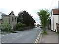
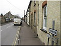
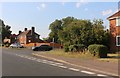
4
Folly Road, Mildenhall
There were two tall trees to the right of the pale house which have been cut down since 2015.
Image: © David Howard
Taken: 9 Aug 2020
0.19 miles
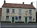
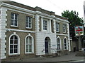
7
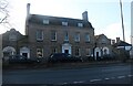
Georgian House on King Street, Mildenhall
Image: © David Howard
Taken: 18 Apr 2021
0.23 miles
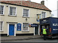
8
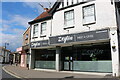
Zeytin Meze and Grill on Mill Street, Mildenhall
This was A Taste of Italia until 2018
Image: © David Howard
Taken: 6 Jul 2021
0.24 miles
9
Folly Road at the junction of Junction Road
It's a road junction, twice.
Image: © David Howard
Taken: 9 Aug 2020
0.24 miles
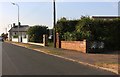
10
Magistrates court
Magistrates court and town sign Mildenhall Suffolk. For view of sign see http://www.geograph.org.uk/photo/822171
Image: © Keith Evans
Taken: 26 May 2008
0.25 miles