IMAGES TAKEN NEAR TO
Woodlands Park, Brandon Road, BURY ST. EDMUNDS, IP28 7JG
Introduction
This page details the photographs taken nearby to Woodlands Park, Brandon Road, IP28 7JG by members of the Geograph project.
The Geograph project started in 2005 with the aim of publishing, organising and preserving representative images for every square kilometre of Great Britain, Ireland and the Isle of Man.

There are currently over 7.5m images from over14,400 individuals and you can help contribute to the project by visiting https://www.geograph.org.uk
Image Map
Images are licensed for reuse under creativecommons.org/licenses/by-sa/2.0
Notes
- Clicking on the map will re-center to the selected point.
- The higher the marker number, the further away the image location is from the centre of the postcode.
Image Listing (5 Images Found)
Images are licensed for reuse under creativecommons.org/licenses/by-sa/2.0
Image
Details
Distance
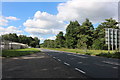
1
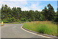
Brandon Road at the junction of the A1065
The Suffolk conifers have arrived and spread way across into Norfolk beyond Thetford.
Image: © David Howard
Taken: 6 Jul 2021
0.09 miles
3
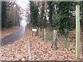
Bridleway
Bridleway near to Mildenhall, Suffolk.
Image: © Keith Evans
Taken: 6 Dec 2016
0.15 miles
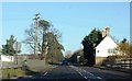
4
A1065 Brandon Road heading south
A small commercial estate on the right.
Image: © Robin Webster
Taken: 7 Mar 2020
0.24 miles
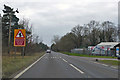
5
Brandon Road, Mildenhall
A row of trees on the left has been removed in the last few years. Fliteline car sales is on the left.
Image: © David Howard
Taken: 19 Jul 2020
0.24 miles