IMAGES TAKEN NEAR TO
Recreation Way, BURY ST. EDMUNDS, IP28 7HG
Introduction
This page details the photographs taken nearby to Recreation Way, IP28 7HG by members of the Geograph project.
The Geograph project started in 2005 with the aim of publishing, organising and preserving representative images for every square kilometre of Great Britain, Ireland and the Isle of Man.

There are currently over 7.5m images from over14,400 individuals and you can help contribute to the project by visiting https://www.geograph.org.uk
Image Map
Images are licensed for reuse under creativecommons.org/licenses/by-sa/2.0
Notes
- Clicking on the map will re-center to the selected point.
- The higher the marker number, the further away the image location is from the centre of the postcode.
Image Listing (216 Images Found)
Images are licensed for reuse under creativecommons.org/licenses/by-sa/2.0
Image
Details
Distance
1
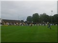
The Recreation Ground, Mildenhall Town FC
The pitch, clubhouse and stand
Image: © Stuart Shepherd
Taken: 14 Jul 2015
0.00 miles
2
Recway, home of Mildenhall Town FC
A team playing in the Eastern Counties League Premier Division.
Image: © Bill Boaden
Taken: 22 Apr 2015
0.03 miles
3

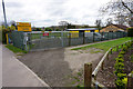
Jubilee Fields car park, Mildenhall
The emptiness of the car park on Boxing Day shows up the frequent reminders about the low barrier at the exit to the car park.
Image: © Bob Jones
Taken: 26 Dec 2007
0.06 miles
4
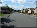
Lark Road, Mildenhall
With the church tower visible in the distance.
When I lived here in the 1970s - in the bungalow behind the lamppost - there were no houses on the left (south) and I would have been standing in an orchard.
Image: © John Goldsmith
Taken: 8 Aug 2010
0.08 miles
5
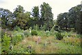
Mildenhall Kingsway Cemetery
Known locally as the 'Old Cemetery' this overgrown burial ground has a number of mown paths, but the graves are in a sorry state.
Image: © Bob Jones
Taken: 7 Aug 2006
0.08 miles
6
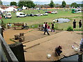
Lark in the Park, Mildenhall
For more details of the event see Image
As well as crayfish fishermen we can see a rather lacklustre classic car display, some tractors, and a few other displays.
The bridge used to take this photo is still on the map but in reality has gone (as seen August 2011).
Image: © John Goldsmith
Taken: 11 Jul 2009
0.09 miles
7
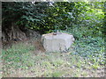
Spigot Mortar emplacement in Mildenhall town centre
Situated in the middle of Mildenhall Old Cemetery.
The cemetery is quite neglected and unkempt.
Image: © Adrian S Pye
Taken: 2 Jul 2017
0.11 miles
9
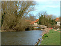
Riverside Walk
This spot is accessed when leaving the rear of Mildenhall Town Centre Car Park. The car park is just to the right hand side of the bridge shown.
Image: © Alma J Walsh
Taken: 30 Mar 2006
0.12 miles
10
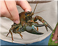
Invading crayfish, Lark in the Park
Thanks to the massive presence of the nearby Mildenhall and Lakenheath USAF bases, Mildenhall town is sometimes jokingly described as the 51st state. You can even spend dollars in the shops. But this american invader is much less welcome - these huge crayfish kill the local wildlife and undermine the river banks. For details of the Lark in the Park event see picture Image
PS. It's a pun. The river is the Lark.
Image: © John Goldsmith
Taken: 11 Jul 2009
0.12 miles