IMAGES TAKEN NEAR TO
Carnoustie Drive, BURY ST. EDMUNDS, IP28 6UU
Introduction
This page details the photographs taken nearby to Carnoustie Drive, IP28 6UU by members of the Geograph project.
The Geograph project started in 2005 with the aim of publishing, organising and preserving representative images for every square kilometre of Great Britain, Ireland and the Isle of Man.

There are currently over 7.5m images from over14,400 individuals and you can help contribute to the project by visiting https://www.geograph.org.uk
Image Map
Images are licensed for reuse under creativecommons.org/licenses/by-sa/2.0
Notes
- Clicking on the map will re-center to the selected point.
- The higher the marker number, the further away the image location is from the centre of the postcode.
Image Listing (19 Images Found)
Images are licensed for reuse under creativecommons.org/licenses/by-sa/2.0
Image
Details
Distance
1
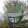
Fornham St Martin cum Fornham St Genevieve village sign
Fornham St Genevieve was amalgamated with St Martin after the church was abandoned after a fire destroyed it in 1752. On the sign the River Lark flows through the scene with fish leaping from the water. Below the name is a black face Suffolk sheep as a reminder of the heydays of the wool trade although the Suffolk was bred for meat rather than wool. The two figures are a reference to the Priory in Fornham St Genevieve.
Image: © Adrian S Pye
Taken: 2 Mar 2021
0.03 miles
2
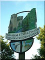
Fornham St. Martin cum Fornham St. Genevieve village sign
Fornham St. Genevieve was amalgamated with St. Martin after the church was abandoned after a fire destroyed it in 1752.
Image: © Adrian S Pye
Taken: 25 Aug 2008
0.03 miles
3
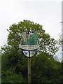
Village sign
Village sign of Fornham St.Martin cum Fornham St.Genevieve Suffolk for overall view see http://www.geograph.org.uk/photo/870038
Image: © Keith Evans
Taken: 3 Jul 2008
0.04 miles
4
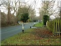
Thetford Road near Fornham St. Martin
This is part of the B1106.
Image: © Robert Edwards
Taken: 28 Jan 2012
0.04 miles
5
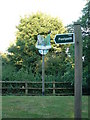
Two signs
Footpath sign and Village sign for Fornham St.Martin Suffolk. For close up of the village sign see http://www.geograph.org.uk/photo/870049
Image: © Keith Evans
Taken: 3 Jul 2008
0.05 miles
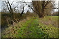
7
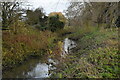
Mill Farm Lock, River Lark
The River Lark was navigable as far as Bury St Edmunds until the early 1900s. Since then the 15 locks between Mildenhall and Bury have fallen into disrepair. This lock is at Fornham St Martin and a private garden extends as far as the fence on the lock wall.
Image: © Bob Jones
Taken: 24 Dec 2007
0.19 miles
9
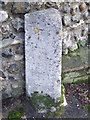
Old Milestone
Old milestone on what was part of the A.134 at Fordham st. Martin, Suffolk. For overall view see http://www.geograph.org.uk/photo/1714897
Image: © Keith Evans
Taken: 17 Feb 2010
0.19 miles