IMAGES TAKEN NEAR TO
Brockley Corner, BURY ST. EDMUNDS, IP28 6UA
Introduction
This page details the photographs taken nearby to Brockley Corner, IP28 6UA by members of the Geograph project.
The Geograph project started in 2005 with the aim of publishing, organising and preserving representative images for every square kilometre of Great Britain, Ireland and the Isle of Man.

There are currently over 7.5m images from over14,400 individuals and you can help contribute to the project by visiting https://www.geograph.org.uk
Image Map
Images are licensed for reuse under creativecommons.org/licenses/by-sa/2.0
Notes
- Clicking on the map will re-center to the selected point.
- The higher the marker number, the further away the image location is from the centre of the postcode.
Image Listing (9 Images Found)
Images are licensed for reuse under creativecommons.org/licenses/by-sa/2.0
Image
Details
Distance
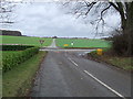
1
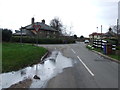
Road Junction
Road junction at Brockley Corner, Suffolk.
Image: © Keith Evans
Taken: 5 Jan 2012
0.02 miles
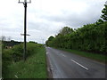
2
Bend
Road scene at Brockley Corner, Suffolk.
Image: © Keith Evans
Taken: 5 Jan 2012
0.02 miles
3
Tumulus
Tumulus known as Hill Of Health at Brockley Corner, Suffolk.
Image: © Keith Evans
Taken: 5 Jan 2012
0.08 miles
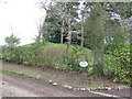
4
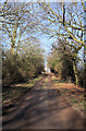
Byway to Culfordheath
This driveable byway links Brockley Corner and the hamlet of Culfordheath, mainly following the edge of the King's Forest.
Image: © Bob Jones
Taken: 21 Jan 2009
0.16 miles
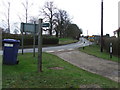
5
Road Junction
Road junction near to Brockley Corner, Suffolk.
Image: © Keith Evans
Taken: 5 Jan 2012
0.21 miles