IMAGES TAKEN NEAR TO
The Street, BURY ST. EDMUNDS, IP28 6ST
Introduction
This page details the photographs taken nearby to The Street, IP28 6ST by members of the Geograph project.
The Geograph project started in 2005 with the aim of publishing, organising and preserving representative images for every square kilometre of Great Britain, Ireland and the Isle of Man.

There are currently over 7.5m images from over14,400 individuals and you can help contribute to the project by visiting https://www.geograph.org.uk
Image Map
Images are licensed for reuse under creativecommons.org/licenses/by-sa/2.0
Notes
- Clicking on the map will re-center to the selected point.
- The higher the marker number, the further away the image location is from the centre of the postcode.
Image Listing (25 Images Found)
Images are licensed for reuse under creativecommons.org/licenses/by-sa/2.0
Image
Details
Distance
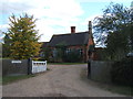
1

Old L.N.E.R. Sign
Old railway sign attached to a house gate at Herrinswell, Suffolk.
Image: © Keith Evans
Taken: 16 Feb 2012
0.01 miles
4
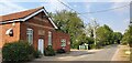
Herringswell Village Hall
The hall can be hired for private functions.
Image: © Barbara Carr
Taken: 6 Oct 2011
0.03 miles
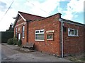
5

Herringswell Village Hall
Herringswell village hall, Suffolk.
Image: © Keith Evans
Taken: 16 Feb 2012
0.03 miles
6
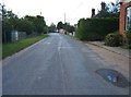
Main street, Herringswell
The Village Hall Image is on the right.
Image: © Barbara Carr
Taken: 6 Oct 2011
0.04 miles
8
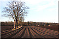
Field boundary, Herringswell
These two recently ploughed fields are linked, with the former field boundary limited to these few trees.
Image: © Bob Jones
Taken: 20 Jan 2009
0.06 miles
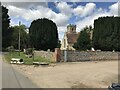
10
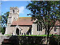
Herringswell St Ethelbert?s church
You would never come this way if you were not visiting the church. It is well off the beaten track. Just inside the gate there is a rather impressive sculpted monument to Herbert Davis (1899). The tower is unusual in that the buttresses are also utilised as stair turrets to the upper stages. The east wall of the tower is supported on columns, arches and flying buttresses internally, easily visible at the west end of the nave. The tower is older by far than the main body of the church as the original was burned down in 1869, but some of the early Norman walls remain: the engaged columns at the eastern corners of what was the chancel, and now is the nave, for example. The furnishings are attractive but of no real age or interest to the architect or historian.
Image: © Adrian S Pye
Taken: 28 Jul 2007
0.14 miles