IMAGES TAKEN NEAR TO
South Street, BURY ST. EDMUNDS, IP28 6QU
Introduction
This page details the photographs taken nearby to South Street, IP28 6QU by members of the Geograph project.
The Geograph project started in 2005 with the aim of publishing, organising and preserving representative images for every square kilometre of Great Britain, Ireland and the Isle of Man.

There are currently over 7.5m images from over14,400 individuals and you can help contribute to the project by visiting https://www.geograph.org.uk
Image Map
Images are licensed for reuse under creativecommons.org/licenses/by-sa/2.0
Notes
- Clicking on the map will re-center to the selected point.
- The higher the marker number, the further away the image location is from the centre of the postcode.
Image Listing (33 Images Found)
Images are licensed for reuse under creativecommons.org/licenses/by-sa/2.0
Image
Details
Distance
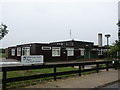
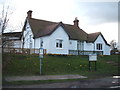
1
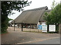
Risby Barn Antiques Centre
Set in a 15th Century thatched barn on South Street
Image: © Stuart Shepherd
Taken: 12 Aug 2008
0.05 miles
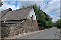
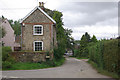
3
South Street, Risby
View north from the entrance to Risby Barn Antiques Centre
Image: © John Myers
Taken: 30 May 2017
0.07 miles
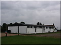
5
Risby Primary School
Risby is a Church of England Voluntary Controlled Primary School
Image: © Stuart Shepherd
Taken: 12 Aug 2008
0.11 miles
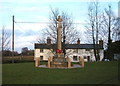
6
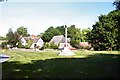
Risby Village Green
There are two greens in Risby; this is the main one.
Image: © Bob Jones
Taken: 22 Jun 2005
0.15 miles
7
Village Hall, Risby
The rear view from the boundary of the cricket field
Image: © Stuart Shepherd
Taken: 12 Aug 2008
0.15 miles
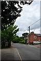
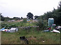
9
Welham Lane, Risby
Welham Lane leads off South Street.
Image: © Stephen McKay
Taken: 25 Sep 2010
0.18 miles