IMAGES TAKEN NEAR TO
Barrow Road, BURY ST. EDMUNDS, IP28 6NN
Introduction
This page details the photographs taken nearby to Barrow Road, IP28 6NN by members of the Geograph project.
The Geograph project started in 2005 with the aim of publishing, organising and preserving representative images for every square kilometre of Great Britain, Ireland and the Isle of Man.

There are currently over 7.5m images from over14,400 individuals and you can help contribute to the project by visiting https://www.geograph.org.uk
Image Map
Images are licensed for reuse under creativecommons.org/licenses/by-sa/2.0
Notes
- Clicking on the map will re-center to the selected point.
- The higher the marker number, the further away the image location is from the centre of the postcode.
Image Listing (47 Images Found)
Images are licensed for reuse under creativecommons.org/licenses/by-sa/2.0
Image
Details
Distance
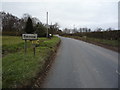
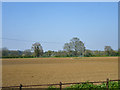
2
Farmland, Broom's Farm
East of Coalpit Lane.
Image: © JThomas
Taken: 19 Mar 2016
0.07 miles
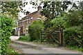
3
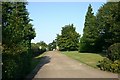
Entrance to Broom's Barn
Broom's Barn, near Barrow in Suffolk, is the UK Centre for Sugar Beet Research.
Image: © Bob Jones
Taken: 8 Aug 2005
0.11 miles
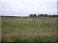
5
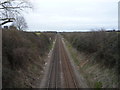
Railway towards Bury St Edmunds and Ipswich
Looking east from the bridge on Coalpit Lane.
Image: © JThomas
Taken: 19 Mar 2016
0.18 miles
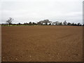
7
Field north of Higham church
Looking from the churchyard.
Image: © Robin Webster
Taken: 8 Apr 2017
0.22 miles
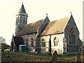
8
St Stephen Higham
The church of St Stephen Higham, Suffolk. For more info see http://www.suffolkchurches.co.uk/highamsteve.htm and other view http://www.geograph.org.uk/photo/2260647
http://www.geograph.org.uk/photo/2260648
http://www.geograph.org.uk/photo/2260637
Image: © Keith Evans
Taken: 3 Feb 2011
0.22 miles
9
Church With A Loo
The church of St Stephen, Higham, Suffolk; sadly I feel the portable loo next to the entrance spoils the look of the church. For more info see http://www.suffolkchurches.co.uk/highamsteve.htm and other view
http://www.geograph.org.uk/photo/2260647
http://www.geograph.org.uk/photo/2260648
http://www.geograph.org.uk/photo/2260632
Image: © Keith Evans
Taken: 3 Feb 2011
0.23 miles
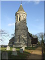
10
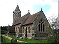
St Stephen's Church Higham Green, Suffolk
This is a Victorian church which was built from scratch in 1861 at a cost of £3,600. It is built in the traditional English style, designed by Sir George Gilbert Scott, from flint and stone. It has a round tower, which includes a belfry stage with blind arcading, and is topped by a conical cap which some seem to regard as a spire.
Image: © Adrian S Pye
Taken: 30 Aug 2007
0.23 miles