IMAGES TAKEN NEAR TO
Bury Road, BURY ST. EDMUNDS, IP28 6LS
Introduction
This page details the photographs taken nearby to Bury Road, IP28 6LS by members of the Geograph project.
The Geograph project started in 2005 with the aim of publishing, organising and preserving representative images for every square kilometre of Great Britain, Ireland and the Isle of Man.

There are currently over 7.5m images from over14,400 individuals and you can help contribute to the project by visiting https://www.geograph.org.uk
Image Map
Images are licensed for reuse under creativecommons.org/licenses/by-sa/2.0
Notes
- Clicking on the map will re-center to the selected point.
- The higher the marker number, the further away the image location is from the centre of the postcode.
Image Listing (20 Images Found)
Images are licensed for reuse under creativecommons.org/licenses/by-sa/2.0
Image
Details
Distance
1
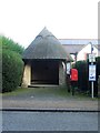
Round Bus Shelter
Round bus shelter at Hengrave, Suffolk.
Image: © Keith Evans
Taken: 6 Dec 2016
0.01 miles
2
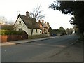
Thatched cottages along the A1101 in Hengrave
This view is from the entrance gates to Hengrave Hall.
Image: © Robert Edwards
Taken: 2 Mar 2011
0.03 miles
5
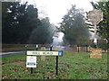
Road Junction
Road junction and village sign at Hengrave, Suffolk.
Image: © Keith Evans
Taken: 6 Dec 2016
0.09 miles
6
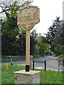
Hengrave village sign
Featured on the sign is Hengrave Hall and standing beside it is Sir Thomas Kitson, a wealthy merchant and Sheriff of London, who had the hall built between 1525, and 1538. The Kitson heraldic arms are carved bottom centre, flanked by two Tudor roses. On the left beneath the hall is the gatehouse with an ironwork gatepost and gate surmounted with a fleur de lys. Behind Sir Thomas is a ship which carried his sister off to America before she married John Washington a direct ancestor of George Washington. https://www.geograph.org.uk/photo/6754928
Image: © Adrian S Pye
Taken: 22 Apr 2007
0.10 miles
7
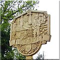
Hengrave cum Flempton village sign
Featured on the sign is Hengrave Hall and standing beside it is Sir Thomas Kitson, a wealthy merchant and Sheriff of London, who had the hall built between 1525, and 1538. The Kitson heraldic arms are carved bottom centre, flanked by two Tudor roses. On the left beneath the hall is the gatehouse with an ironwork gatepost and gate surmounted with a fleur de lys. Behind Sir Thomas is a ship which carried his sister off to America before she married John Washington a direct ancestor of George Washington. https://www.geograph.org.uk/photo/4292876
Image: © Adrian S Pye
Taken: 19 Dec 2020
0.10 miles
8
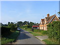
Down Mill Lane
Looking back towards Hengrave village.
Image: © Stuart Shepherd
Taken: 8 Aug 2009
0.11 miles
9
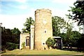
Church of St John Lateran (or The Reconciliation)
This round-towered church in the grounds of Hengrave Hall long ago ceased to be a parish church. The tower is 38ft (12m) high and 12ft (4m) in internal diameter. According to Bill Goode it is middle Saxon; Munro Cautley agrees that it is probably pre-Conquest, but Pevsner regards it as probably early Norman. It is unusual not only for its girth but for its pronounced taper. http://www.suffolkchurches.co.uk/hengrave.htm
Image: © Tiger
Taken: Unknown
0.12 miles
10
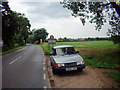
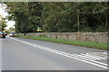
A1101 Entering Hengrave
Photo taken looking northwest.
Image: © David Wright
Taken: 6 Jul 2003
0.12 miles